Münster geodata
Münster (Bavaria) is a seat of a fourth-order administrative division; located in Germany in Europe/Berlin (GMT+2) time zone. In our database, there are 11009 cities with bigger population. Compared to other cities in Germany, 87.5% of cities are located further ↑North; 65.5% of cities are located further ←West and 77.4% of cities have lower elevation than Münster. Note1
Administrative division(s):
- Level 1: Bavaria
- Level 2: Swabia
- Level 3: Landkreis Donau-Ries
- Level 4: Münster


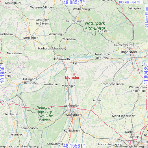
Münster GPS coordinates[2]
48° 37' 21.108" North, 10° 54' 6.192" East
| Map corner | latitude | longitude |
|---|---|---|
| Upper-left | 49.08517°, | 10.1986° |
| Center: | 48.62253°, | 10.90172° |
| Lower-right: | 48.15561°, | 11.60485° |
| Map W x H: | 103.4×103.4 km | = 64.2×64.2mi |
| max Lat: | 55.01917° ⇑87.5% North |
| Münster: | 48.62253° |
| min Lat: | ⇓12.5% South 47.40724° |
| min Long | Münster | max Long |
| 5.92978° | 10.90172° | 14.98853° |
| W 65.5%⇐ | ⇒34.5% E |
Elevation
Elevation of Münster is 415 m = 1362 ft, and this is 165.9 m = 544 ft above average elevation for this country.
| Max E: |
1256 m = 4121 ft | 22.6% |
| Münster | 415 m 1362 ft | |
| Avg. | 249.1 m = 817 ft | |
Min E: |
-5 m = -16 ft | 77.4% |
See also: Germany elevation on elevation.city.
Geographical zone
Münster is located in North temperate zone (between Tropic of Cancer and the Arctic Circle). Distance of this North polar circle is 1994.9 km =1239.6 mi to North.| Distance of | km | miles | from Münster |
|---|---|---|---|
| North Pole | 4600.7 | 2858.7 | to North |
| Arctic Circle | 1994.9 | 1239.6 | to North |
| Tropic Cancer | 2800.4 | 1740.1 | to South |
| Equator | 5406.3 | 3359.3 | to South |


Nearby cities:
15 places around Münster: (largest is in red/bold)
• Allmannshofen
6.9 km =4.3 mi,  260°
260°
• Asbach-Bäumenheim
9.2 km =5.7 mi,  317°
317°
• Ehingen
7.9 km =4.9 mi,  251°
251°
• Ellgau
3.6 km =2.2 mi,  225°
225°
• Genderkingen
8.7 km =5.4 mi,  351°
351°
• Holzheim
3.7 km =2.3 mi,  110°
110°
• Kühlenthal
8.8 km =5.5 mi, 225°
• Meitingen
9.3 km =5.8 mi,  203°
203°
• Mertingen
8 km =5 mi,  298°
298°
• Niederschönenfeld
10.7 km =6.6 mi,  12°
12°
• Nordendorf
6 km =3.7 mi,  239°
239°
• Oberndorf
5.8 km =3.6 mi,  334°
334°
• Rain
7.6 km =4.7 mi, 7°
• Thierhaupten
6.4 km =4 mi,  175°
175°
• Westendorf
7.2 km =4.5 mi,  218°
218°
Sources, notices
• [Note1] Compared only with cities in Germany existing in our database
• [Src1] Map data: © OpenStreetMap contributors (CC-BY-SA)
• [Src2] Other city data from geonames.org with taken over terms of usage.
• [Src3] Geographical zone / Annual Mean Temperature by Robert A. Rohde @ Wikipedia
