Allmannshofen geodata
Allmannshofen (Bavaria) is a seat of a fourth-order administrative division; located in Germany in Europe/Berlin (GMT+2) time zone. With population of 828 people, there are 7783 cities with bigger population in this country. Compared to other cities in Germany, 87.7% of cities are located further ↑North; 64.2% of cities are located further ←West and 80.8% of cities have lower elevation than Allmannshofen. Note1
Administrative division(s):
- Level 1: Bavaria
- Level 2: Swabia
- Level 3: Landkreis Augsburg
- Level 4: Allmannshofen


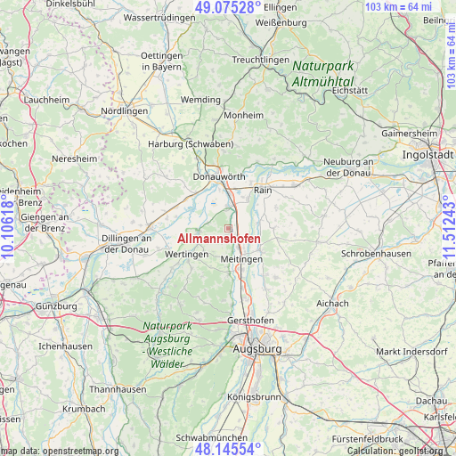
Allmannshofen GPS coordinates[2]
48° 36' 45.18" North, 10° 48' 33.48" East
| Map corner | latitude | longitude |
|---|---|---|
| Upper-left | 49.07528°, | 10.10618° |
| Center: | 48.61255°, | 10.8093° |
| Lower-right: | 48.14554°, | 11.51243° |
| Map W x H: | 103.4×103.4 km | = 64.2×64.2mi |
| max Lat: | 55.01917° ⇑87.7% North |
| Allmannshofen: | 48.61255° |
| min Lat: | ⇓12.3% South 47.40724° |
| min Long | Allmannshofen | max Long |
| 5.92978° | 10.8093° | 14.98853° |
| W 64.2%⇐ | ⇒35.8% E |
Elevation
Elevation of Allmannshofen is 438 m = 1437 ft, and this is 188.9 m = 620 ft above average elevation for this country.
| Max E: |
1256 m = 4121 ft | 19.2% |
| Allmannshofen | 438 m 1437 ft | |
| Avg. | 249.1 m = 817 ft | |
Min E: |
-5 m = -16 ft | 80.8% |
See also: Germany elevation on elevation.city.
Geographical zone
Allmannshofen is located in North temperate zone (between Tropic of Cancer and the Arctic Circle). Distance of this North polar circle is 1996 km =1240.3 mi to North.| Distance of | km | miles | from Allmannshofen |
|---|---|---|---|
| North Pole | 4601.9 | 2859.5 | to North |
| Arctic Circle | 1996 | 1240.3 | to North |
| Tropic Cancer | 2799.3 | 1739.4 | to South |
| Equator | 5405.2 | 3358.6 | to South |


Nearby cities:
15 places around Allmannshofen: (largest is in red/bold)
• Asbach-Bäumenheim
7.9 km =4.9 mi,  3°
3°
• Biberbach
10.5 km =6.5 mi,  179°
179°
• Buttenwiesen
7 km =4.3 mi,  258°
258°
• Ehingen
1.6 km =1 mi,  206°
206°
• Ellgau
4.4 km =2.7 mi,  108°
108°
• Holzheim
10.2 km =6.3 mi,  90°
90°
• Kühlenthal
5.1 km =3.2 mi,  173°
173°
• Meitingen
8 km =5 mi,  157°
157°
• Mertingen
4.9 km =3 mi,  356°
356°
• Münster
6.9 km =4.3 mi,  80°
80°
• Nordendorf
2.6 km =1.6 mi,  140°
140°
• Oberndorf
7.6 km =4.7 mi,  34°
34°
• Thierhaupten
9 km =5.6 mi,  125°
125°
• Wertingen
10.9 km =6.8 mi,  239°
239°
• Westendorf
5 km =3.1 mi,  152°
152°
Sources, notices
• [Note1] Compared only with cities in Germany existing in our database
• [Src1] Map data: © OpenStreetMap contributors (CC-BY-SA)
• [Src2] Other city data from geonames.org with taken over terms of usage.
• [Src3] Geographical zone / Annual Mean Temperature by Robert A. Rohde @ Wikipedia
