Ellgau geodata
Ellgau (Bavaria) is a seat of a fourth-order administrative division; located in Germany in Europe/Berlin (GMT+2) time zone. With population of 1,004 people, there are 7165 cities with bigger population in this country. Compared to other cities in Germany, 87.8% of cities are located further ↑North; 65% of cities are located further ←West and 78.2% of cities have lower elevation than Ellgau. Note1
Administrative division(s):
- Level 1: Bavaria
- Level 2: Swabia
- Level 3: Landkreis Augsburg
- Level 4: Ellgau


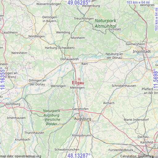
Ellgau GPS coordinates[2]
48° 36' 0" North, 10° 52' 0.012" East
| Map corner | latitude | longitude |
|---|---|---|
| Upper-left | 49.06285°, | 10.16355° |
| Center: | 48.6°, | 10.86667° |
| Lower-right: | 48.13287°, | 11.5698° |
| Map W x H: | 103.4×103.4 km | = 64.2×64.2mi |
| max Lat: | 55.01917° ⇑87.8% North |
| Ellgau: | 48.6° |
| min Lat: | ⇓12.2% South 47.40724° |
| min Long | Ellgau | max Long |
| 5.92978° | 10.86667° | 14.98853° |
| W 65%⇐ | ⇒35% E |
Elevation
Elevation of Ellgau is 420 m = 1378 ft, and this is 170.9 m = 561 ft above average elevation for this country.
| Max E: |
1256 m = 4121 ft | 21.8% |
| Ellgau | 420 m 1378 ft | |
| Avg. | 249.1 m = 817 ft | |
Min E: |
-5 m = -16 ft | 78.2% |
See also: Germany elevation on elevation.city.
Geographical zone
Ellgau is located in North temperate zone (between Tropic of Cancer and the Arctic Circle). Distance of this North polar circle is 1997.4 km =1241.1 mi to North.| Distance of | km | miles | from Ellgau |
|---|---|---|---|
| North Pole | 4603.2 | 2860.3 | to North |
| Arctic Circle | 1997.4 | 1241.1 | to North |
| Tropic Cancer | 2797.9 | 1738.5 | to South |
| Equator | 5403.8 | 3357.8 | to South |


Nearby cities:
15 places around Ellgau: (largest is in red/bold)
• Allmannshofen
4.4 km =2.7 mi,  288°
288°
• Asbach-Bäumenheim
10 km =6.2 mi,  338°
338°
• Biberbach
10 km =6.2 mi,  203°
203°
• Ehingen
4.9 km =3 mi,  270°
270°
• Holzheim
6.1 km =3.8 mi,  78°
78°
• Kühlenthal
5.2 km =3.2 mi,  224°
224°
• Meitingen
6.1 km =3.8 mi,  190°
190°
• Mertingen
7.8 km =4.8 mi,  324°
324°
• Münster
3.6 km =2.2 mi,  45°
45°
• Nordendorf
2.6 km =1.6 mi,  257°
257°
• Oberndorf
7.7 km =4.8 mi,  0°
0°
• Rain
10.7 km =6.6 mi,  19°
19°
• Thierhaupten
4.9 km =3 mi,  141°
141°
• Todtenweis
10.3 km =6.4 mi,  153°
153°
• Westendorf
3.7 km =2.3 mi,  211°
211°
Sources, notices
• [Note1] Compared only with cities in Germany existing in our database
• [Src1] Map data: © OpenStreetMap contributors (CC-BY-SA)
• [Src2] Other city data from geonames.org with taken over terms of usage.
• [Src3] Geographical zone / Annual Mean Temperature by Robert A. Rohde @ Wikipedia
