Rennertshofen geodata
Rennertshofen (Bavaria) is a populated place; located in Germany in Europe/Berlin (GMT+2) time zone. With population of 5,013 people, there are 2825 cities with bigger population in this country. Compared to other cities in Germany, 85.8% of cities are located further ↑North; 67.6% of cities are located further ←West and 75.5% of cities have lower elevation than Rennertshofen. Note1
Administrative division(s):
- Level 1: Bavaria
- Level 2: Upper Bavaria
- Level 3: Landkreis Neuburg-Schrobenhausen
- Level 4: Rennertshofen, Markt


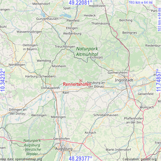
Rennertshofen GPS coordinates[2]
48° 45' 33.948" North, 11° 2' 43.584" East
| Map corner | latitude | longitude |
|---|---|---|
| Upper-left | 49.22081°, | 10.34232° |
| Center: | 48.75943°, | 11.04544° |
| Lower-right: | 48.29377°, | 11.74857° |
| Map W x H: | 103.1×103.1 km | = 64.1×64.1mi |
| max Lat: | 55.01917° ⇑85.8% North |
| Rennertshofen: | 48.75943° |
| min Lat: | ⇓14.2% South 47.40724° |
| min Long | Rennertshofen | max Long |
| 5.92978° | 11.04544° | 14.98853° |
| W 67.6%⇐ | ⇒32.4% E |
Elevation
Elevation of Rennertshofen is 401 m = 1316 ft, and this is 151.9 m = 498 ft above average elevation for this country.
| Max E: |
1256 m = 4121 ft | 24.5% |
| Rennertshofen | 401 m 1316 ft | |
| Avg. | 249.1 m = 817 ft | |
Min E: |
-5 m = -16 ft | 75.5% |
See also: Germany elevation on elevation.city.
Geographical zone
Rennertshofen is located in North temperate zone (between Tropic of Cancer and the Arctic Circle). Distance of this North polar circle is 1979.6 km =1230.1 mi to North.| Distance of | km | miles | from Rennertshofen |
|---|---|---|---|
| North Pole | 4585.5 | 2849.3 | to North |
| Arctic Circle | 1979.6 | 1230.1 | to North |
| Tropic Cancer | 2815.6 | 1749.5 | to South |
| Equator | 5421.5 | 3368.8 | to South |


Nearby cities:
15 places around Rennertshofen: (largest is in red/bold)
• Adelschlag
15.6 km =9.7 mi,  54°
54°
• Bergheim
15.5 km =9.6 mi,  89°
89°
• Burgheim
6.9 km =4.3 mi,  198°
198°
• Daiting
10.9 km =6.8 mi,  289°
289°
• Egweil
14 km =8.7 mi,  79°
79°
• Ehekirchen
14.6 km =9.1 mi,  164°
164°
• Genderkingen
13.6 km =8.5 mi,  240°
240°
• Marxheim
7.6 km =4.7 mi,  254°
254°
• Neuburg an der Donau
10.8 km =6.7 mi,  106°
106°
• Niederschönenfeld
9.5 km =5.9 mi, 239°
• Oberhausen
6.4 km =4 mi,  130°
130°
• Rain
12.2 km =7.6 mi,  230°
230°
• Rohrenfels
11.5 km =7.1 mi, 134°
• Rögling
12.3 km =7.6 mi,  325°
325°
• Tagmersheim
8.6 km =5.3 mi,  317°
317°
Sources, notices
• [Note1] Compared only with cities in Germany existing in our database
• [Src1] Map data: © OpenStreetMap contributors (CC-BY-SA)
• [Src2] Other city data from geonames.org with taken over terms of usage.
• [Src3] Geographical zone / Annual Mean Temperature by Robert A. Rohde @ Wikipedia
