Marienheide geodata
Marienheide (North Rhine-Westphalia) is a seat of a fourth-order administrative division; located in Germany in Europe/Berlin (GMT+2) time zone. With population of 13,759 people, there are 1166 cities with bigger population in this country. Compared to other cities in Germany, 59.5% of cities are located further ↓South; 86.4% of cities are located further →East and 69.7% of cities have lower elevation than Marienheide. Note1
Administrative division(s):
- Level 1: North Rhine-Westphalia
- Level 2: Regierungsbezirk Köln
- Level 3: Oberbergischer Kreis
- Level 4: Marienheide


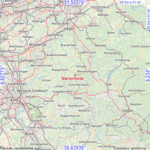
Marienheide GPS coordinates[2]
51° 4' 59.412" North, 7° 31' 51.132" East
| Map corner | latitude | longitude |
|---|---|---|
| Upper-left | 51.52276°, | 6.82775° |
| Center: | 51.08317°, | 7.53087° |
| Lower-right: | 50.63936°, | 8.234° |
| Map W x H: | 98.2×98.2 km | = 61×61mi |
| max Lat: | 55.01917° ⇑40.5% North |
| Marienheide: | 51.08317° |
| min Lat: | ⇓59.5% South 47.40724° |
| min Long | Marienheide | max Long |
| 5.92978° | 7.53087° | 14.98853° |
| W 13.6%⇐ | ⇒86.4% E |
Elevation
Elevation of Marienheide is 356 m = 1168 ft, and this is 106.9 m = 351 ft above average elevation for this country.
| Max E: |
1256 m = 4121 ft | 30.3% |
| Marienheide | 356 m 1168 ft | |
| Avg. | 249.1 m = 817 ft | |
Min E: |
-5 m = -16 ft | 69.7% |
See also: Germany elevation on elevation.city.
Geographical zone
Marienheide is located in North temperate zone (between Tropic of Cancer and the Arctic Circle). Distance of this North polar circle is 1721.3 km =1069.6 mi to North.| Distance of | km | miles | from Marienheide |
|---|---|---|---|
| North Pole | 4327.1 | 2688.7 | to North |
| Arctic Circle | 1721.3 | 1069.6 | to North |
| Tropic Cancer | 3074 | 1910.1 | to South |
| Equator | 5679.9 | 3529.3 | to South |


Nearby cities:
15 places around Marienheide: (largest is in red/bold)
• Bergneustadt
10.9 km =6.8 mi,  126°
126°
• Drolshagen
18.2 km =11.3 mi,  111°
111°
• Engelskirchen
13.3 km =8.3 mi,  217°
217°
• Gummersbach
6.8 km =4.2 mi,  159°
159°
• Halver
11.7 km =7.3 mi,  348°
348°
• Herscheid
18.3 km =11.4 mi,  54°
54°
• Hückeswagen
15 km =9.3 mi,  299°
299°
• Kierspe
7 km =4.3 mi,  36°
36°
• Lindlar
12.8 km =8 mi,  236°
236°
• Lüdenscheid
16.6 km =10.3 mi,  23°
23°
• Meinerzhagen
8.6 km =5.3 mi,  71°
71°
• Radevormwald
17.8 km =11.1 mi,  318°
318°
• Schalksmühle
17.6 km =10.9 mi,  359°
359°
• Wiehl
14.9 km =9.3 mi,  174°
174°
• Wipperfürth
9.9 km =6.2 mi,  291°
291°
Sources, notices
• [Note1] Compared only with cities in Germany existing in our database
• [Src1] Map data: © OpenStreetMap contributors (CC-BY-SA)
• [Src2] Other city data from geonames.org with taken over terms of usage.
• [Src3] Geographical zone / Annual Mean Temperature by Robert A. Rohde @ Wikipedia
