Kürten geodata
Kürten (North Rhine-Westphalia) is a seat of a fourth-order administrative division; located in Germany in Europe/Berlin (GMT+2) time zone. With population of 20,103 people, there are 773 cities with bigger population in this country. Compared to other cities in Germany, 58.9% of cities are located further ↓South; 90.6% of cities are located further →East and 56.1% of cities have higher elevation than Kürten. Note1
Administrative division(s):
- Level 1: North Rhine-Westphalia
- Level 2: Regierungsbezirk Köln
- Level 3: Rheinisch-Bergischer Kreis
- Level 4: Kürten


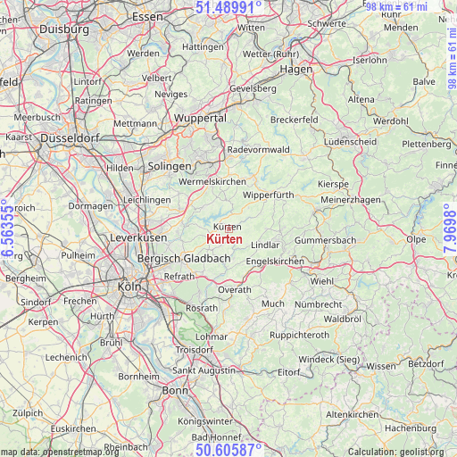
Kürten GPS coordinates[2]
51° 3' 0" North, 7° 16' 0.012" East
| Map corner | latitude | longitude |
|---|---|---|
| Upper-left | 51.48991°, | 6.56355° |
| Center: | 51.05°, | 7.26667° |
| Lower-right: | 50.60587°, | 7.9698° |
| Map W x H: | 98.3×98.3 km | = 61.1×61.1mi |
| max Lat: | 55.01917° ⇑41.1% North |
| Kürten: | 51.05° |
| min Lat: | ⇓58.9% South 47.40724° |
| min Long | Kürten | max Long |
| 5.92978° | 7.26667° | 14.98853° |
| W 9.4%⇐ | ⇒90.6% E |
Elevation
Elevation of Kürten is 181 m = 594 ft, and this is 68.1 m = 223 ft below average elevation for this country.
| Max E: |
1256 m = 4121 ft | 56.1% |
| Avg. | 249.1 m = 817 ft | |
| Kürten | 181 m = 594 ft | |
Min E: |
-5 m = -16 ft | 43.9% |
See also: Germany elevation on elevation.city.
Geographical zone
Kürten is located in North temperate zone (between Tropic of Cancer and the Arctic Circle). Distance of this North polar circle is 1724.9 km =1071.8 mi to North.| Distance of | km | miles | from Kürten |
|---|---|---|---|
| North Pole | 4330.8 | 2691 | to North |
| Arctic Circle | 1724.9 | 1071.8 | to North |
| Tropic Cancer | 3070.3 | 1907.8 | to South |
| Equator | 5676.2 | 3527 | to South |


Nearby cities:
15 places around Kürten: (largest is in red/bold)
• Bergisch Gladbach
11.8 km =7.3 mi,  232°
232°
• Burscheid
11.3 km =7 mi,  289°
289°
• Engelskirchen
12.4 km =7.7 mi,  123°
123°
• Hückeswagen
12.4 km =7.7 mi,  26°
26°
• Leichlingen
18.4 km =11.4 mi, 289°
• Lindlar
8.5 km =5.3 mi,  113°
113°
• Odenthal
10.6 km =6.6 mi,  259°
259°
• Opladen
18.5 km =11.5 mi,  276°
276°
• Overath
13.1 km =8.1 mi,  174°
174°
• Radevormwald
18.1 km =11.2 mi,  21°
21°
• Rath
18.6 km =11.6 mi,  220°
220°
• Remscheid
15.3 km =9.5 mi,  340°
340°
• Rösrath
18.2 km =11.3 mi,  199°
199°
• Wermelskirchen
10.6 km =6.6 mi, 340°
• Wipperfürth
11.8 km =7.3 mi,  51°
51°
Sources, notices
• [Note1] Compared only with cities in Germany existing in our database
• [Src1] Map data: © OpenStreetMap contributors (CC-BY-SA)
• [Src2] Other city data from geonames.org with taken over terms of usage.
• [Src3] Geographical zone / Annual Mean Temperature by Robert A. Rohde @ Wikipedia
