Gesundbrunnen geodata
Gesundbrunnen (Berlin) is a section of populated place; located in Germany in Europe/Berlin (GMT+2) time zone. With population of 84,789 people, there are 114 cities with bigger population in this country. Compared to other cities in Germany, 78.1% of cities are located further ↓South; 95% of cities are located further ←West and 77.9% of cities have higher elevation than Gesundbrunnen. Note1


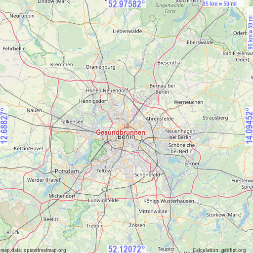
Gesundbrunnen GPS coordinates[2]
52° 33' 1.26" North, 13° 23' 29.004" East
| Map corner | latitude | longitude |
|---|---|---|
| Upper-left | 52.97582°, | 12.68827° |
| Center: | 52.55035°, | 13.39139° |
| Lower-right: | 52.12072°, | 14.09452° |
| Map W x H: | 95.1×95.1 km | = 59.1×59.1mi |
| max Lat: | 55.01917° ⇑21.9% North |
| Gesundbrunnen: | 52.55035° |
| min Lat: | ⇓78.1% South 47.40724° |
| min Long | Gesundbrunnen | max Long |
| 5.92978° | 13.39139° | 14.98853° |
| W 95%⇐ | ⇒5% E |
Elevation
Elevation of Gesundbrunnen is 53 m = 174 ft, and this is 196.1 m = 643 ft below average elevation for this country.
| Max E: |
1256 m = 4121 ft | 77.9% |
| Avg. | 249.1 m = 817 ft | |
| Gesundbrunnen | 53 m = 174 ft | |
Min E: |
-5 m = -16 ft | 22.1% |
See also: Gesundbrunnen elevation on elevation.city.
Geographical zone
Gesundbrunnen is located in North temperate zone (between Tropic of Cancer and the Arctic Circle). Distance of this North polar circle is 1558.1 km =968.2 mi to North.| Distance of | km | miles | from Gesundbrunnen |
|---|---|---|---|
| North Pole | 4164 | 2587.4 | to North |
| Arctic Circle | 1558.1 | 968.2 | to North |
| Tropic Cancer | 3237.1 | 2011.4 | to South |
| Equator | 5843.1 | 3630.7 | to South |


Nearby cities:
15 places around Gesundbrunnen: (largest is in red/bold)
• Berlin
3.2 km =2 mi,  155°
155°
• Hansaviertel
4.9 km =3 mi,  223°
223°
• Heinersdorf
3.9 km =2.4 mi,  52°
52°
• Kreuzberg
5.7 km =3.5 mi,  171°
171°
• Mitte
3.5 km =2.2 mi, 164°
• Moabit
4.4 km =2.7 mi,  232°
232°
• Niederschönhausen
3.9 km =2.4 mi,  11°
11°
• Pankow
2.2 km =1.4 mi,  18°
18°
• Prenzlauer Berg
2.6 km =1.6 mi,  119°
119°
• Reinickendorf
4.3 km =2.7 mi,  294°
294°
• Rosenthal
5.6 km =3.5 mi,  350°
350°
• Tiergarten
4.1 km =2.5 mi,  204°
204°
• Wedding
2.4 km =1.5 mi,  262°
262°
• Weißensee
5.1 km =3.2 mi,  82°
82°
• Wilhelmsruh
4.4 km =2.7 mi,  339°
339°
In other languages:
- In France: Berlin-Gesundbrunnen
- In German: Berlin-Gesundbrunnen
- In Russian: Гезундбруннен
Sources, notices
• [Note1] Compared only with cities in Germany existing in our database
• [Src1] Map data: © OpenStreetMap contributors (CC-BY-SA)
• [Src2] Other city data from geonames.org with taken over terms of usage.
• [Src3] Geographical zone / Annual Mean Temperature by Robert A. Rohde @ Wikipedia
