Preetz geodata
Preetz (Schleswig-Holstein) is a populated place; located in Germany in Europe/Berlin (GMT+2) time zone. With population of 15,768 people, there are 1016 cities with bigger population in this country. Compared to other cities in Germany, 95.6% of cities are located further ↓South; 54.9% of cities are located further ←West and 86.6% of cities have higher elevation than Preetz. Note1


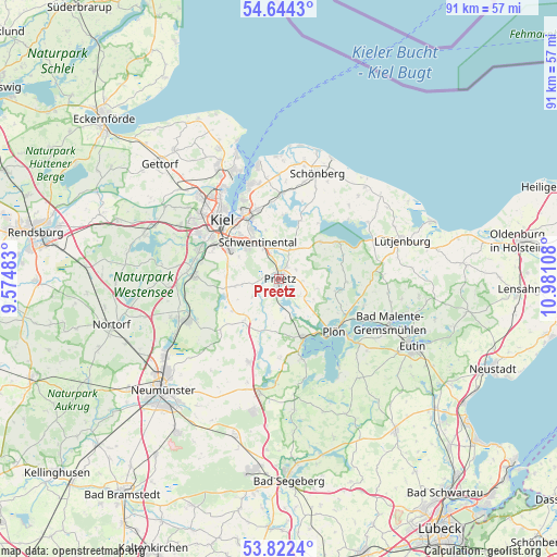
Preetz GPS coordinates[2]
54° 14' 7.44" North, 10° 16' 40.62" East
| Map corner | latitude | longitude |
|---|---|---|
| Upper-left | 54.6443°, | 9.57483° |
| Center: | 54.2354°, | 10.27795° |
| Lower-right: | 53.8224°, | 10.98108° |
| Map W x H: | 91.4×91.4 km | = 56.8×56.8mi |
| max Lat: | 55.01917° ⇑4.4% North |
| Preetz: | 54.2354° |
| min Lat: | ⇓95.6% South 47.40724° |
| min Long | Preetz | max Long |
| 5.92978° | 10.27795° | 14.98853° |
| W 54.9%⇐ | ⇒45.1% E |
Elevation
Elevation of Preetz is 31 m = 102 ft, and this is 218.1 m = 716 ft below average elevation for this country.
| Max E: |
1256 m = 4121 ft | 86.6% |
| Avg. | 249.1 m = 817 ft | |
| Preetz | 31 m = 102 ft | |
Min E: |
-5 m = -16 ft | 13.4% |
See also: Germany elevation on elevation.city.
Geographical zone
Preetz is located in North temperate zone (between Tropic of Cancer and the Arctic Circle). Distance of this North polar circle is 1370.8 km =851.8 mi to North.| Distance of | km | miles | from Preetz |
|---|---|---|---|
| North Pole | 3976.7 | 2471 | to North |
| Arctic Circle | 1370.8 | 851.8 | to North |
| Tropic Cancer | 3424.5 | 2127.9 | to South |
| Equator | 6030.4 | 3747.1 | to South |


Nearby cities:
15 places around Preetz: (largest is in red/bold)
• Barmissen
7.3 km =4.5 mi,  237°
237°
• Großbarkau
7.2 km =4.5 mi,  268°
268°
• Honigsee
6.2 km =3.9 mi, 267°
• Kirchbarkau
9.1 km =5.7 mi,  252°
252°
• Klausdorf
9.2 km =5.7 mi,  332°
332°
• Kühren
4.2 km =2.6 mi,  196°
196°
• Lehmkuhlen
5.8 km =3.6 mi,  92°
92°
• Löptin
7 km =4.3 mi,  214°
214°
• Nettelsee
8.6 km =5.3 mi,  220°
220°
• Pohnsdorf
1.9 km =1.2 mi,  283°
283°
• Postfeld
5.1 km =3.2 mi, 236°
• Raisdorf
5.4 km =3.4 mi,  339°
339°
• Rastorf
3.5 km =2.2 mi,  5°
5°
• Schellhorn
1.2 km =0.7 mi,  122°
122°
• Wahlstorf (Dorf)
6.4 km =4 mi,  170°
170°
Sources, notices
• [Note1] Compared only with cities in Germany existing in our database
• [Src1] Map data: © OpenStreetMap contributors (CC-BY-SA)
• [Src2] Other city data from geonames.org with taken over terms of usage.
• [Src3] Geographical zone / Annual Mean Temperature by Robert A. Rohde @ Wikipedia
