Prebitz geodata
Prebitz (Bavaria) is a seat of a fourth-order administrative division; located in Germany in Europe/Berlin (GMT+2) time zone. With population of 1,148 people, there are 6704 cities with bigger population in this country. Compared to other cities in Germany, 68.2% of cities are located further ↑North; 76.9% of cities are located further ←West and 78.9% of cities have lower elevation than Prebitz. Note1
Administrative division(s):
- Level 1: Bavaria
- Level 2: Upper Franconia
- Level 3: Landkreis Bayreuth
- Level 4: Prebitz


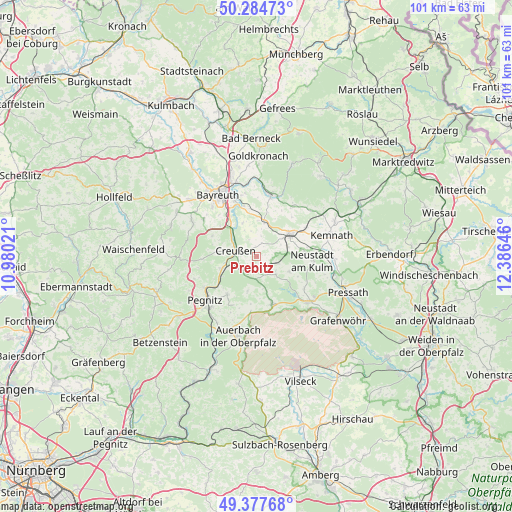
Prebitz GPS coordinates[2]
49° 49' 59.988" North, 11° 40' 59.988" East
| Map corner | latitude | longitude |
|---|---|---|
| Upper-left | 50.28473°, | 10.98021° |
| Center: | 49.83333°, | 11.68333° |
| Lower-right: | 49.37768°, | 12.38646° |
| Map W x H: | 100.9×100.9 km | = 62.7×62.7mi |
| max Lat: | 55.01917° ⇑68.2% North |
| Prebitz: | 49.83333° |
| min Lat: | ⇓31.8% South 47.40724° |
| min Long | Prebitz | max Long |
| 5.92978° | 11.68333° | 14.98853° |
| W 76.9%⇐ | ⇒23.1% E |
Elevation
Elevation of Prebitz is 426 m = 1398 ft, and this is 176.9 m = 580 ft above average elevation for this country.
| Max E: |
1256 m = 4121 ft | 21.1% |
| Prebitz | 426 m 1398 ft | |
| Avg. | 249.1 m = 817 ft | |
Min E: |
-5 m = -16 ft | 78.9% |
See also: Germany elevation on elevation.city.
Geographical zone
Prebitz is located in North temperate zone (between Tropic of Cancer and the Arctic Circle). Distance of this North polar circle is 1860.2 km =1155.9 mi to North.| Distance of | km | miles | from Prebitz |
|---|---|---|---|
| North Pole | 4466.1 | 2775.1 | to North |
| Arctic Circle | 1860.2 | 1155.9 | to North |
| Tropic Cancer | 2935 | 1823.7 | to South |
| Equator | 5540.9 | 3443 | to South |


Nearby cities:
15 places around Prebitz: (largest is in red/bold)
• Bayreuth
14.8 km =9.2 mi,  329°
329°
• Creußen
4.3 km =2.7 mi,  287°
287°
• Emtmannsberg
7.1 km =4.4 mi,  337°
337°
• Gesees
13.1 km =8.1 mi,  304°
304°
• Haag
9.7 km =6 mi, 294°
• Kirchenpingarten
13.2 km =8.2 mi,  32°
32°
• Kirchenthumbach
9.9 km =6.2 mi,  162°
162°
• Neunkirchen am Main
10.3 km =6.4 mi,  345°
345°
• Pegnitz
13.6 km =8.5 mi,  228°
228°
• Schlammersdorf
5.2 km =3.2 mi,  135°
135°
• Schnabelwaid
7.6 km =4.7 mi,  251°
251°
• Seybothenreuth
6.9 km =4.3 mi,  13°
13°
• Speichersdorf
8.2 km =5.1 mi,  58°
58°
• Speinshart
10.9 km =6.8 mi,  116°
116°
• Vorbach
4 km =2.5 mi,  109°
109°
Sources, notices
• [Note1] Compared only with cities in Germany existing in our database
• [Src1] Map data: © OpenStreetMap contributors (CC-BY-SA)
• [Src2] Other city data from geonames.org with taken over terms of usage.
• [Src3] Geographical zone / Annual Mean Temperature by Robert A. Rohde @ Wikipedia
