Creußen geodata
Creußen (Bavaria) is a populated place; located in Germany in Europe/Berlin (GMT+2) time zone. With population of 4,871 people, there are 2875 cities with bigger population in this country. Compared to other cities in Germany, 67.9% of cities are located further ↑North; 76.1% of cities are located further ←West and 79.5% of cities have lower elevation than Creußen. Note1
Administrative division(s):
- Level 1: Bavaria
- Level 2: Upper Franconia
- Level 3: Landkreis Bayreuth
- Level 4: Creußen


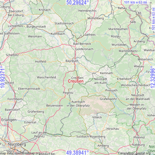
Creußen GPS coordinates[2]
49° 50' 41.82" North, 11° 37' 36.588" East
| Map corner | latitude | longitude |
|---|---|---|
| Upper-left | 50.29624°, | 10.92371° |
| Center: | 49.84495°, | 11.62683° |
| Lower-right: | 49.38941°, | 12.32996° |
| Map W x H: | 100.8×100.8 km | = 62.6×62.6mi |
| max Lat: | 55.01917° ⇑67.9% North |
| Creußen: | 49.84495° |
| min Lat: | ⇓32.1% South 47.40724° |
| min Long | Creußen | max Long |
| 5.92978° | 11.62683° | 14.98853° |
| W 76.1%⇐ | ⇒23.9% E |
Elevation
Elevation of Creußen is 430 m = 1411 ft, and this is 180.9 m = 594 ft above average elevation for this country.
| Max E: |
1256 m = 4121 ft | 20.5% |
| Creußen | 430 m 1411 ft | |
| Avg. | 249.1 m = 817 ft | |
Min E: |
-5 m = -16 ft | 79.5% |
See also: Germany elevation on elevation.city.
Geographical zone
Creußen is located in North temperate zone (between Tropic of Cancer and the Arctic Circle). Distance of this North polar circle is 1858.9 km =1155.1 mi to North.| Distance of | km | miles | from Creußen |
|---|---|---|---|
| North Pole | 4464.8 | 2774.3 | to North |
| Arctic Circle | 1858.9 | 1155.1 | to North |
| Tropic Cancer | 2936.3 | 1824.5 | to South |
| Equator | 5542.2 | 3443.8 | to South |


Nearby cities:
15 places around Creußen: (largest is in red/bold)
• Bayreuth
11.9 km =7.4 mi,  343°
343°
• Emtmannsberg
5.4 km =3.4 mi,  13°
13°
• Gesees
9.1 km =5.7 mi,  312°
312°
• Glashütten
13.6 km =8.5 mi,  290°
290°
• Haag
5.5 km =3.4 mi,  300°
300°
• Kirchenthumbach
12.8 km =8 mi,  146°
146°
• Mistelbach
11.1 km =6.9 mi, 312°
• Neunkirchen am Main
8.8 km =5.5 mi, 9°
• Pegnitz
12 km =7.5 mi,  210°
210°
• Prebitz
4.3 km =2.7 mi,  107°
107°
• Schlammersdorf
9.1 km =5.7 mi,  123°
123°
• Schnabelwaid
4.8 km =3 mi,  220°
220°
• Seybothenreuth
7.8 km =4.8 mi,  46°
46°
• Speichersdorf
11.4 km =7.1 mi,  75°
75°
• Vorbach
8.3 km =5.2 mi, 108°
Sources, notices
• [Note1] Compared only with cities in Germany existing in our database
• [Src1] Map data: © OpenStreetMap contributors (CC-BY-SA)
• [Src2] Other city data from geonames.org with taken over terms of usage.
• [Src3] Geographical zone / Annual Mean Temperature by Robert A. Rohde @ Wikipedia
