Pösing geodata
Pösing (Bavaria) is a seat of a fourth-order administrative division; located in Germany in Europe/Berlin (GMT+2) time zone. With population of 969 people, there are 7278 cities with bigger population in this country. Compared to other cities in Germany, 79.9% of cities are located further ↑North; 88.3% of cities are located further ←West and 71.8% of cities have lower elevation than Pösing. Note1
Administrative division(s):
- Level 1: Bavaria
- Level 2: Upper Palatinate
- Level 3: Landkreis Cham
- Level 4: Pösing


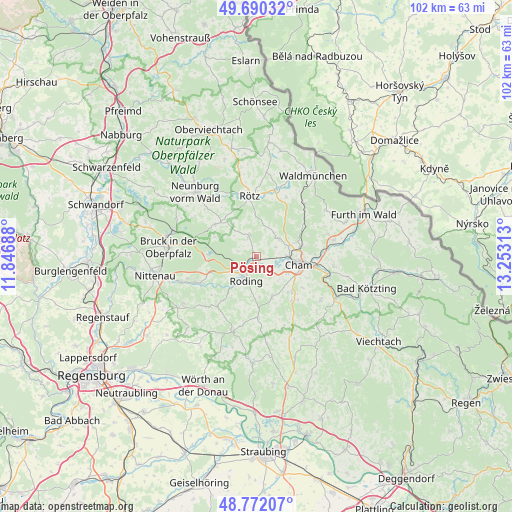
Pösing GPS coordinates[2]
49° 13' 59.988" North, 12° 33' 0" East
| Map corner | latitude | longitude |
|---|---|---|
| Upper-left | 49.69032°, | 11.84688° |
| Center: | 49.23333°, | 12.55° |
| Lower-right: | 48.77207°, | 13.25313° |
| Map W x H: | 102.1×102.1 km | = 63.4×63.4mi |
| max Lat: | 55.01917° ⇑79.9% North |
| Pösing: | 49.23333° |
| min Lat: | ⇓20.1% South 47.40724° |
| min Long | Pösing | max Long |
| 5.92978° | 12.55° | 14.98853° |
| W 88.3%⇐ | ⇒11.7% E |
Elevation
Elevation of Pösing is 373 m = 1224 ft, and this is 123.9 m = 406 ft above average elevation for this country.
| Max E: |
1256 m = 4121 ft | 28.2% |
| Pösing | 373 m 1224 ft | |
| Avg. | 249.1 m = 817 ft | |
Min E: |
-5 m = -16 ft | 71.8% |
See also: Germany elevation on elevation.city.
Geographical zone
Pösing is located in North temperate zone (between Tropic of Cancer and the Arctic Circle). Distance of this North polar circle is 1926.9 km =1197.3 mi to North.| Distance of | km | miles | from Pösing |
|---|---|---|---|
| North Pole | 4532.8 | 2816.6 | to North |
| Arctic Circle | 1926.9 | 1197.3 | to North |
| Tropic Cancer | 2868.3 | 1782.3 | to South |
| Equator | 5474.2 | 3401.5 | to South |


Nearby cities:
15 places around Pösing: (largest is in red/bold)
• Cham
7.7 km =4.8 mi,  96°
96°
• Chamerau
15 km =9.3 mi, 104°
• Michelsneukirchen
12.3 km =7.6 mi,  179°
179°
• Neukirchen-Balbini
10.4 km =6.5 mi,  307°
307°
• Pemfling
6.1 km =3.8 mi,  52°
52°
• Roding
4.9 km =3 mi,  206°
206°
• Runding
15.5 km =9.6 mi, 97°
• Rötz
12.3 km =7.6 mi,  353°
353°
• Schorndorf
8.7 km =5.4 mi,  158°
158°
• Schönthal
13.5 km =8.4 mi,  15°
15°
• Stamsried
4.1 km =2.5 mi,  339°
339°
• Traitsching
11.8 km =7.3 mi,  141°
141°
• Waffenbrunn
9.2 km =5.7 mi,  66°
66°
• Walderbach
13.3 km =8.3 mi,  245°
245°
• Willmering
8.7 km =5.4 mi,  77°
77°
Sources, notices
• [Note1] Compared only with cities in Germany existing in our database
• [Src1] Map data: © OpenStreetMap contributors (CC-BY-SA)
• [Src2] Other city data from geonames.org with taken over terms of usage.
• [Src3] Geographical zone / Annual Mean Temperature by Robert A. Rohde @ Wikipedia
