Bunde geodata
Bunde (Lower Saxony) is a seat of a fourth-order administrative division; located in Germany in Europe/Berlin (GMT+2) time zone. With population of 7,588 people, there are 2046 cities with bigger population in this country. Compared to other cities in Germany, 82.7% of cities are located further ↓South; 90.6% of cities are located further →East and 96.2% of cities have higher elevation than Bunde. Note1


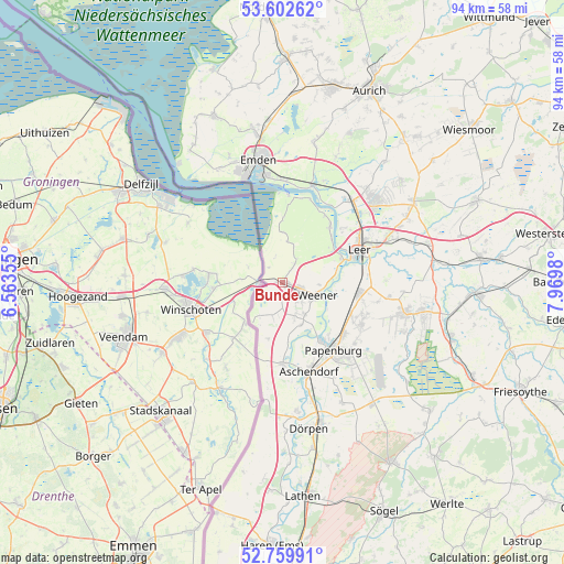
Bunde GPS coordinates[2]
53° 10' 59.988" North, 7° 16' 0.012" East
| Map corner | latitude | longitude |
|---|---|---|
| Upper-left | 53.60262°, | 6.56355° |
| Center: | 53.18333°, | 7.26667° |
| Lower-right: | 52.75991°, | 7.9698° |
| Map W x H: | 93.7×93.7 km | = 58.2×58.2mi |
| max Lat: | 55.01917° ⇑17.3% North |
| Bunde: | 53.18333° |
| min Lat: | ⇓82.7% South 47.40724° |
| min Long | Bunde | max Long |
| 5.92978° | 7.26667° | 14.98853° |
| W 9.4%⇐ | ⇒90.6% E |
Elevation
Elevation of Bunde is 6 m = 20 ft, and this is 243.1 m = 798 ft below average elevation for this country.
| Max E: |
1256 m = 4121 ft | 96.2% |
| Avg. | 249.1 m = 817 ft | |
| Bunde | 6 m = 20 ft | |
Min E: |
-5 m = -16 ft | 3.8% |
See also: Germany elevation on elevation.city.
Geographical zone
Bunde is located in North temperate zone (between Tropic of Cancer and the Arctic Circle). Distance of this North polar circle is 1487.7 km =924.4 mi to North.| Distance of | km | miles | from Bunde |
|---|---|---|---|
| North Pole | 4093.6 | 2543.6 | to North |
| Arctic Circle | 1487.7 | 924.4 | to North |
| Tropic Cancer | 3307.5 | 2055.2 | to South |
| Equator | 5913.4 | 3674.4 | to South |


Nearby cities:
15 places around Bunde: (largest is in red/bold)
• Brinkum
22 km =13.7 mi,  65°
65°
• Dörpen
24.6 km =15.3 mi,  171°
171°
• Emden
20.8 km =12.9 mi,  349°
349°
• Heede
21.4 km =13.3 mi, 174°
• Holtland
23.8 km =14.8 mi,  62°
62°
• Jemgum
12.1 km =7.5 mi,  39°
39°
• Leer
14 km =8.7 mi, 67°
• Lehe
20.9 km =13 mi, 167°
• Nenndorf
11.2 km =7 mi,  157°
157°
• Neulehe
22.2 km =13.8 mi,  153°
153°
• Nortmoor
21.5 km =13.4 mi, 71°
• Ostrhauderfehn
24 km =14.9 mi,  103°
103°
• Papenburg
14.9 km =9.3 mi,  142°
142°
• Rhede
13.7 km =8.5 mi,  178°
178°
• Weener
6 km =3.7 mi,  111°
111°
Sources, notices
• [Note1] Compared only with cities in Germany existing in our database
• [Src1] Map data: © OpenStreetMap contributors (CC-BY-SA)
• [Src2] Other city data from geonames.org with taken over terms of usage.
• [Src3] Geographical zone / Annual Mean Temperature by Robert A. Rohde @ Wikipedia
