Reinickendorf geodata
Reinickendorf (Berlin) is a section of populated place; located in Germany in Europe/Berlin (GMT+2) time zone. With population of 75,414 people, there are 137 cities with bigger population in this country. Compared to other cities in Germany, 78.3% of cities are located further ↓South; 94.6% of cities are located further ←West and 82% of cities have higher elevation than Reinickendorf. Note1


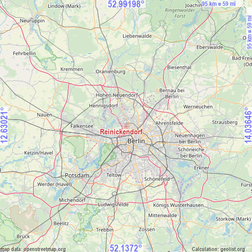
Reinickendorf GPS coordinates[2]
52° 34' 0.012" North, 13° 19' 59.988" East
| Map corner | latitude | longitude |
|---|---|---|
| Upper-left | 52.99198°, | 12.63021° |
| Center: | 52.56667°, | 13.33333° |
| Lower-right: | 52.1372°, | 14.03646° |
| Map W x H: | 95×95 km | = 59×59mi |
| max Lat: | 55.01917° ⇑21.7% North |
| Reinickendorf: | 52.56667° |
| min Lat: | ⇓78.3% South 47.40724° |
| min Long | Reinickendorf | max Long |
| 5.92978° | 13.33333° | 14.98853° |
| W 94.6%⇐ | ⇒5.4% E |
Elevation
Elevation of Reinickendorf is 42 m = 138 ft, and this is 207.1 m = 679 ft below average elevation for this country.
| Max E: |
1256 m = 4121 ft | 82% |
| Avg. | 249.1 m = 817 ft | |
| Reinickendorf | 42 m = 138 ft | |
Min E: |
-5 m = -16 ft | 18% |
See also: Reinickendorf elevation on elevation.city.
Geographical zone
Reinickendorf is located in North temperate zone (between Tropic of Cancer and the Arctic Circle). Distance of this North polar circle is 1556.3 km =967 mi to North.| Distance of | km | miles | from Reinickendorf |
|---|---|---|---|
| North Pole | 4162.2 | 2586.3 | to North |
| Arctic Circle | 1556.3 | 967 | to North |
| Tropic Cancer | 3238.9 | 2012.6 | to South |
| Equator | 5844.9 | 3631.9 | to South |


Nearby cities:
15 places around Reinickendorf: (largest is in red/bold)
• Charlottenburg-Nord
4.8 km =3 mi,  213°
213°
• Gesundbrunnen
4.3 km =2.7 mi,  114°
114°
• Hansaviertel
5.4 km =3.4 mi,  173°
173°
• Lübars
5.6 km =3.5 mi,  13°
13°
• Moabit
4.5 km =2.8 mi,  175°
175°
• Märkisches Viertel
3.9 km =2.4 mi,  24°
24°
• Niederschönhausen
5.1 km =3.2 mi,  66°
66°
• Pankow
4.6 km =2.9 mi,  86°
86°
• Rosenthal
4.7 km =2.9 mi,  39°
39°
• Siemensstadt
5.6 km =3.5 mi,  238°
238°
• Tegel
2.9 km =1.8 mi,  291°
291°
• Waidmannslust
4.6 km =2.9 mi,  348°
348°
• Wedding
2.6 km =1.6 mi,  144°
144°
• Wilhelmsruh
3.3 km =2.1 mi,  46°
46°
• Wittenau
3.1 km =1.9 mi,  344°
344°
Sources, notices
• [Note1] Compared only with cities in Germany existing in our database
• [Src1] Map data: © OpenStreetMap contributors (CC-BY-SA)
• [Src2] Other city data from geonames.org with taken over terms of usage.
• [Src3] Geographical zone / Annual Mean Temperature by Robert A. Rohde @ Wikipedia
