Wilhelmsruh geodata
Wilhelmsruh (Berlin) is a section of populated place; located in Germany in Europe/Berlin (GMT+2) time zone. With population of 7,079 people, there are 2164 cities with bigger population in this country. Compared to other cities in Germany, 78.6% of cities are located further ↓South; 94.9% of cities are located further ←West and 81% of cities have higher elevation than Wilhelmsruh. Note1


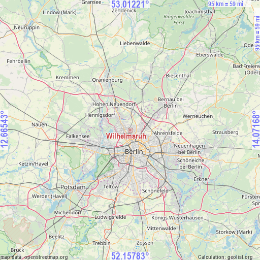
Wilhelmsruh GPS coordinates[2]
52° 35' 13.56" North, 13° 22' 6.78" East
| Map corner | latitude | longitude |
|---|---|---|
| Upper-left | 53.01221°, | 12.66543° |
| Center: | 52.5871°, | 13.36855° |
| Lower-right: | 52.15783°, | 14.07168° |
| Map W x H: | 95×95 km | = 59×59mi |
| max Lat: | 55.01917° ⇑21.4% North |
| Wilhelmsruh: | 52.5871° |
| min Lat: | ⇓78.6% South 47.40724° |
| min Long | Wilhelmsruh | max Long |
| 5.92978° | 13.36855° | 14.98853° |
| W 94.9%⇐ | ⇒5.1% E |
Elevation
Elevation of Wilhelmsruh is 44 m = 144 ft, and this is 205.1 m = 673 ft below average elevation for this country.
| Max E: |
1256 m = 4121 ft | 81% |
| Avg. | 249.1 m = 817 ft | |
| Wilhelmsruh | 44 m = 144 ft | |
Min E: |
-5 m = -16 ft | 19% |
See also: Germany elevation on elevation.city.
Geographical zone
Wilhelmsruh is located in North temperate zone (between Tropic of Cancer and the Arctic Circle). Distance of this North polar circle is 1554 km =965.6 mi to North.| Distance of | km | miles | from Wilhelmsruh |
|---|---|---|---|
| North Pole | 4159.9 | 2584.8 | to North |
| Arctic Circle | 1554 | 965.6 | to North |
| Tropic Cancer | 3241.2 | 2014 | to South |
| Equator | 5847.1 | 3633.2 | to South |


Nearby cities:
15 places around Wilhelmsruh: (largest is in red/bold)
• Blankenfelde
3.8 km =2.4 mi,  22°
22°
• Französisch Buchholz
4.5 km =2.8 mi,  67°
67°
• Gesundbrunnen
4.4 km =2.7 mi,  159°
159°
• Heinersdorf
5 km =3.1 mi,  110°
110°
• Hermsdorf
5.2 km =3.2 mi,  305°
305°
• Lübars
3.4 km =2.1 mi,  342°
342°
• Märkisches Viertel
1.5 km =0.9 mi,  329°
329°
• Niederschönhausen
2.3 km =1.4 mi,  96°
96°
• Pankow
3 km =1.9 mi,  131°
131°
• Reinickendorf
3.3 km =2.1 mi,  226°
226°
• Rosenthal
1.5 km =0.9 mi, 23°
• Tegel
5.2 km =3.2 mi,  256°
256°
• Waidmannslust
4 km =2.5 mi,  303°
303°
• Wedding
4.5 km =2.8 mi,  190°
190°
• Wittenau
3.3 km =2.1 mi,  281°
281°
Sources, notices
• [Note1] Compared only with cities in Germany existing in our database
• [Src1] Map data: © OpenStreetMap contributors (CC-BY-SA)
• [Src2] Other city data from geonames.org with taken over terms of usage.
• [Src3] Geographical zone / Annual Mean Temperature by Robert A. Rohde @ Wikipedia
