Ottenbach geodata
Ottenbach (Baden-Württemberg) is a seat of a fourth-order administrative division; located in Germany in Europe/Berlin (GMT+2) time zone. With population of 2,459 people, there are 4486 cities with bigger population in this country. Compared to other cities in Germany, 86% of cities are located further ↑North; 53.6% of cities are located further →East and 74.2% of cities have lower elevation than Ottenbach. Note1
Administrative division(s):
- Level 1: Baden-Württemberg
- Level 2: Regierungsbezirk Stuttgart
- Level 3: Landkreis Göppingen
- Level 4: Ottenbach


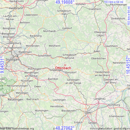
Ottenbach GPS coordinates[2]
48° 44' 11.364" North, 9° 44' 54.384" East
| Map corner | latitude | longitude |
|---|---|---|
| Upper-left | 49.19808°, | 9.04531° |
| Center: | 48.73649°, | 9.74844° |
| Lower-right: | 48.27062°, | 10.45157° |
| Map W x H: | 103.1×103.1 km | = 64.1×64.1mi |
| max Lat: | 55.01917° ⇑86% North |
| Ottenbach: | 48.73649° |
| min Lat: | ⇓14% South 47.40724° |
| min Long | Ottenbach | max Long |
| 5.92978° | 9.74844° | 14.98853° |
| W 46.4%⇐ | ⇒53.6% E |
Elevation
Elevation of Ottenbach is 391 m = 1283 ft, and this is 141.9 m = 466 ft above average elevation for this country.
| Max E: |
1256 m = 4121 ft | 25.8% |
| Ottenbach | 391 m 1283 ft | |
| Avg. | 249.1 m = 817 ft | |
Min E: |
-5 m = -16 ft | 74.2% |
See also: Germany elevation on elevation.city.
Geographical zone
Ottenbach is located in North temperate zone (between Tropic of Cancer and the Arctic Circle). Distance of this North polar circle is 1982.2 km =1231.7 mi to North.| Distance of | km | miles | from Ottenbach |
|---|---|---|---|
| North Pole | 4588.1 | 2850.9 | to North |
| Arctic Circle | 1982.2 | 1231.7 | to North |
| Tropic Cancer | 2813.1 | 1748 | to South |
| Equator | 5419 | 3367.2 | to South |


Nearby cities:
15 places around Ottenbach: (largest is in red/bold)
• Birenbach
6.5 km =4 mi,  280°
280°
• Börtlingen
8.8 km =5.5 mi, 282°
• Donzdorf
7.3 km =4.5 mi,  141°
141°
• Eislingen
5.5 km =3.4 mi,  213°
213°
• Gingen an der Fils
8.9 km =5.5 mi,  164°
164°
• Göppingen
8 km =5 mi,  242°
242°
• Lorch
8 km =5 mi,  328°
328°
• Rechberghausen
7.7 km =4.8 mi,  265°
265°
• Salach
5 km =3.1 mi,  189°
189°
• Schlat
9.8 km =6.1 mi,  198°
198°
• Schwäbisch Gmünd
7.9 km =4.9 mi,  27°
27°
• Süßen
6.4 km =4 mi,  175°
175°
• Waldstetten
6.3 km =3.9 mi,  58°
58°
• Wangen
10.1 km =6.3 mi, 265°
• Wäschenbeuren
5.2 km =3.2 mi,  300°
300°
Sources, notices
• [Note1] Compared only with cities in Germany existing in our database
• [Src1] Map data: © OpenStreetMap contributors (CC-BY-SA)
• [Src2] Other city data from geonames.org with taken over terms of usage.
• [Src3] Geographical zone / Annual Mean Temperature by Robert A. Rohde @ Wikipedia
