Eislingen geodata
Eislingen (Baden-Württemberg) is a populated place; located in Germany in Europe/Berlin (GMT+2) time zone. With population of 20,585 people, there are 749 cities with bigger population in this country. Compared to other cities in Germany, 86.5% of cities are located further ↑North; 54.2% of cities are located further →East and 67.4% of cities have lower elevation than Eislingen. Note1
Administrative division(s):
- Level 1: Baden-Württemberg
- Level 2: Regierungsbezirk Stuttgart
- Level 3: Landkreis Göppingen
- Level 4: Eislingen/ Fils


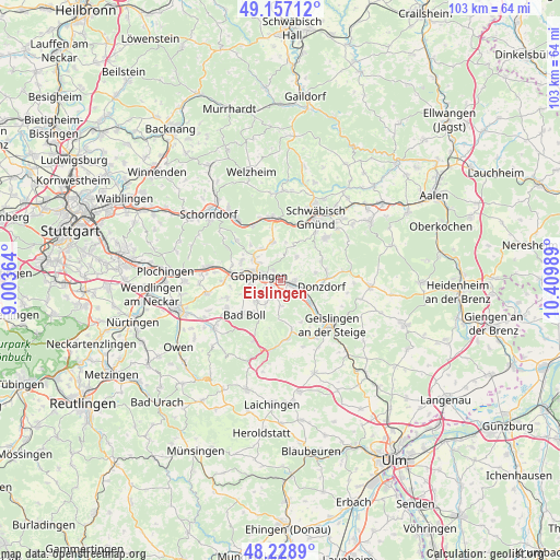
Eislingen GPS coordinates[2]
48° 41' 42.54" North, 9° 42' 24.336" East
| Map corner | latitude | longitude |
|---|---|---|
| Upper-left | 49.15712°, | 9.00364° |
| Center: | 48.69515°, | 9.70676° |
| Lower-right: | 48.2289°, | 10.40989° |
| Map W x H: | 103.2×103.2 km | = 64.1×64.1mi |
| max Lat: | 55.01917° ⇑86.5% North |
| Eislingen: | 48.69515° |
| min Lat: | ⇓13.5% South 47.40724° |
| min Long | Eislingen | max Long |
| 5.92978° | 9.70676° | 14.98853° |
| W 45.8%⇐ | ⇒54.2% E |
Elevation
Elevation of Eislingen is 338 m = 1109 ft, and this is 88.9 m = 292 ft above average elevation for this country.
| Max E: |
1256 m = 4121 ft | 32.6% |
| Eislingen | 338 m 1109 ft | |
| Avg. | 249.1 m = 817 ft | |
Min E: |
-5 m = -16 ft | 67.4% |
See also: Germany elevation on elevation.city.
Geographical zone
Eislingen is located in North temperate zone (between Tropic of Cancer and the Arctic Circle). Distance of this North polar circle is 1986.8 km =1234.5 mi to North.| Distance of | km | miles | from Eislingen |
|---|---|---|---|
| North Pole | 4592.7 | 2853.8 | to North |
| Arctic Circle | 1986.8 | 1234.5 | to North |
| Tropic Cancer | 2808.5 | 1745.1 | to South |
| Equator | 5414.4 | 3364.4 | to South |


Nearby cities:
15 places around Eislingen: (largest is in red/bold)
• Birenbach
6.7 km =4.2 mi,  330°
330°
• Donzdorf
7.7 km =4.8 mi,  98°
98°
• Dürnau
8 km =5 mi,  220°
220°
• Eschenbach
5.4 km =3.4 mi,  209°
209°
• Gammelshausen
7.4 km =4.6 mi, 213°
• Gingen an der Fils
6.7 km =4.2 mi,  125°
125°
• Göppingen
4.1 km =2.5 mi,  283°
283°
• Heiningen
5.6 km =3.5 mi,  228°
228°
• Ottenbach
5.5 km =3.4 mi,  33°
33°
• Rechberghausen
6.1 km =3.8 mi,  310°
310°
• Salach
2.3 km =1.4 mi, 98°
• Schlat
4.7 km =2.9 mi,  180°
180°
• Süßen
4 km =2.5 mi,  116°
116°
• Wangen
7.9 km =4.9 mi,  298°
298°
• Wäschenbeuren
7.3 km =4.5 mi,  348°
348°
In other languages:
- In German: Eislingen/Fils
- In Italian: Eislingen/Fils
- In Russian: Айзлинген
- In Chinese: 艾斯林根
Sources, notices
• [Note1] Compared only with cities in Germany existing in our database
• [Src1] Map data: © OpenStreetMap contributors (CC-BY-SA)
• [Src2] Other city data from geonames.org with taken over terms of usage.
• [Src3] Geographical zone / Annual Mean Temperature by Robert A. Rohde @ Wikipedia
