Donzdorf geodata
Donzdorf (Baden-Württemberg) is a populated place; located in Germany in Europe/Berlin (GMT+2) time zone. With population of 11,051 people, there are 1495 cities with bigger population in this country. Compared to other cities in Germany, 86.6% of cities are located further ↑North; 52.6% of cities are located further →East and 76.5% of cities have lower elevation than Donzdorf. Note1
Administrative division(s):
- Level 1: Baden-Württemberg
- Level 2: Regierungsbezirk Stuttgart
- Level 3: Landkreis Göppingen
- Level 4: Donzdorf


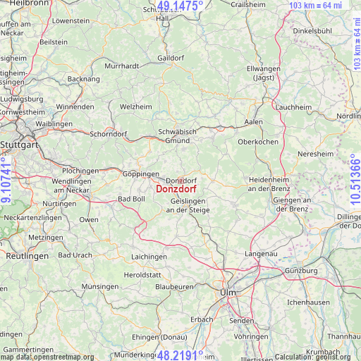
Donzdorf GPS coordinates[2]
48° 41' 7.584" North, 9° 48' 37.908" East
| Map corner | latitude | longitude |
|---|---|---|
| Upper-left | 49.1475°, | 9.10741° |
| Center: | 48.68544°, | 9.81053° |
| Lower-right: | 48.2191°, | 10.51366° |
| Map W x H: | 103.2×103.2 km | = 64.1×64.1mi |
| max Lat: | 55.01917° ⇑86.6% North |
| Donzdorf: | 48.68544° |
| min Lat: | ⇓13.4% South 47.40724° |
| min Long | Donzdorf | max Long |
| 5.92978° | 9.81053° | 14.98853° |
| W 47.4%⇐ | ⇒52.6% E |
Elevation
Elevation of Donzdorf is 409 m = 1342 ft, and this is 159.9 m = 525 ft above average elevation for this country.
| Max E: |
1256 m = 4121 ft | 23.5% |
| Donzdorf | 409 m 1342 ft | |
| Avg. | 249.1 m = 817 ft | |
Min E: |
-5 m = -16 ft | 76.5% |
See also: Germany elevation on elevation.city.
Geographical zone
Donzdorf is located in North temperate zone (between Tropic of Cancer and the Arctic Circle). Distance of this North polar circle is 1987.9 km =1235.2 mi to North.| Distance of | km | miles | from Donzdorf |
|---|---|---|---|
| North Pole | 4593.7 | 2854.4 | to North |
| Arctic Circle | 1987.9 | 1235.2 | to North |
| Tropic Cancer | 2807.4 | 1744.4 | to South |
| Equator | 5413.3 | 3363.7 | to South |


Nearby cities:
15 places around Donzdorf: (largest is in red/bold)
• Bad Überkingen
9.6 km =6 mi,  186°
186°
• Böhmenkirch
9 km =5.6 mi,  91°
91°
• Deggingen
11.9 km =7.4 mi,  214°
214°
• Eislingen
7.7 km =4.8 mi,  278°
278°
• Eschenbach
10.9 km =6.8 mi,  250°
250°
• Geislingen an der Steige
6.9 km =4.3 mi,  169°
169°
• Gingen an der Fils
3.6 km =2.2 mi,  217°
217°
• Göppingen
11.8 km =7.3 mi, 279°
• Heiningen
12.1 km =7.5 mi,  257°
257°
• Kuchen
5.6 km =3.5 mi, 188°
• Ottenbach
7.3 km =4.5 mi,  321°
321°
• Salach
5.4 km =3.4 mi, 277°
• Schlat
8.5 km =5.3 mi,  244°
244°
• Süßen
4.1 km =2.5 mi, 260°
• Waldstetten
9 km =5.6 mi,  5°
5°
Sources, notices
• [Note1] Compared only with cities in Germany existing in our database
• [Src1] Map data: © OpenStreetMap contributors (CC-BY-SA)
• [Src2] Other city data from geonames.org with taken over terms of usage.
• [Src3] Geographical zone / Annual Mean Temperature by Robert A. Rohde @ Wikipedia
