Waldstetten geodata
Waldstetten (Baden-Württemberg) is a seat of a fourth-order administrative division; located in Germany in Europe/Berlin (GMT+2) time zone. With population of 7,316 people, there are 2113 cities with bigger population in this country. Compared to other cities in Germany, 85.7% of cities are located further ↑North; 52.4% of cities are located further →East and 73% of cities have lower elevation than Waldstetten. Note1
Administrative division(s):
- Level 1: Baden-Württemberg
- Level 2: Regierungsbezirk Stuttgart
- Level 3: Ostalbkreis
- Level 4: Waldstetten


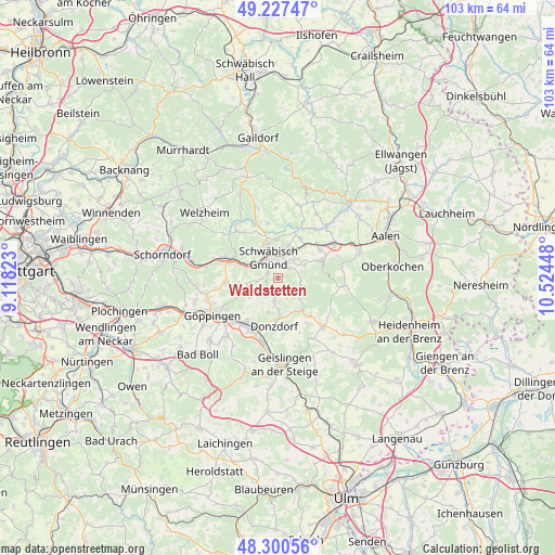
Waldstetten GPS coordinates[2]
48° 45' 58.14" North, 9° 49' 16.86" East
| Map corner | latitude | longitude |
|---|---|---|
| Upper-left | 49.22747°, | 9.11823° |
| Center: | 48.76615°, | 9.82135° |
| Lower-right: | 48.30056°, | 10.52448° |
| Map W x H: | 103.1×103.1 km | = 64.1×64.1mi |
| max Lat: | 55.01917° ⇑85.7% North |
| Waldstetten: | 48.76615° |
| min Lat: | ⇓14.3% South 47.40724° |
| min Long | Waldstetten | max Long |
| 5.92978° | 9.82135° | 14.98853° |
| W 47.6%⇐ | ⇒52.4% E |
Elevation
Elevation of Waldstetten is 382 m = 1253 ft, and this is 132.9 m = 436 ft above average elevation for this country.
| Max E: |
1256 m = 4121 ft | 27% |
| Waldstetten | 382 m 1253 ft | |
| Avg. | 249.1 m = 817 ft | |
Min E: |
-5 m = -16 ft | 73% |
See also: Germany elevation on elevation.city.
Geographical zone
Waldstetten is located in North temperate zone (between Tropic of Cancer and the Arctic Circle). Distance of this North polar circle is 1978.9 km =1229.6 mi to North.| Distance of | km | miles | from Waldstetten |
|---|---|---|---|
| North Pole | 4584.8 | 2848.9 | to North |
| Arctic Circle | 1978.9 | 1229.6 | to North |
| Tropic Cancer | 2816.4 | 1750 | to South |
| Equator | 5422.3 | 3369.3 | to South |


Nearby cities:
15 places around Waldstetten: (largest is in red/bold)
• Böbingen an der Rems
9.4 km =5.8 mi,  50°
50°
• Donzdorf
9 km =5.6 mi,  185°
185°
• Durlangen
10.2 km =6.3 mi,  349°
349°
• Göggingen
11.5 km =7.1 mi,  23°
23°
• Heubach
8.7 km =5.4 mi,  70°
70°
• Iggingen
8.4 km =5.2 mi,  30°
30°
• Leinzell
10.1 km =6.3 mi, 23°
• Lorch
10.2 km =6.3 mi,  290°
290°
• Mutlangen
6.9 km =4.3 mi, 345°
• Ottenbach
6.3 km =3.9 mi,  238°
238°
• Salach
10.3 km =6.4 mi,  216°
216°
• Schwäbisch Gmünd
4.1 km =2.5 mi,  335°
335°
• Süßen
10.8 km =6.7 mi,  206°
206°
• Täferrot
9.4 km =5.8 mi,  7°
7°
• Wäschenbeuren
9.8 km =6.1 mi,  265°
265°
Sources, notices
• [Note1] Compared only with cities in Germany existing in our database
• [Src1] Map data: © OpenStreetMap contributors (CC-BY-SA)
• [Src2] Other city data from geonames.org with taken over terms of usage.
• [Src3] Geographical zone / Annual Mean Temperature by Robert A. Rohde @ Wikipedia
