Hellenhahn-Schellenberg geodata
Hellenhahn-Schellenberg (Rheinland-Pfalz) is a seat of a fourth-order administrative division; located in Germany in Europe/Berlin (GMT+2) time zone. With population of 1,315 people, there are 6264 cities with bigger population in this country. Compared to other cities in Germany, 50.2% of cities are located further ↑North; 76.7% of cities are located further →East and 85.5% of cities have lower elevation than Hellenhahn-Schellenberg. Note1
Administrative division(s):
- Level 1: Rheinland-Pfalz
- Level 3: Westerwaldkreis
- Level 4: Hellenhahn-Schellenberg
Current local time in Hellenhahn-Schellenberg:
03:53 PM, TuesdayDifference from your time zone: hours


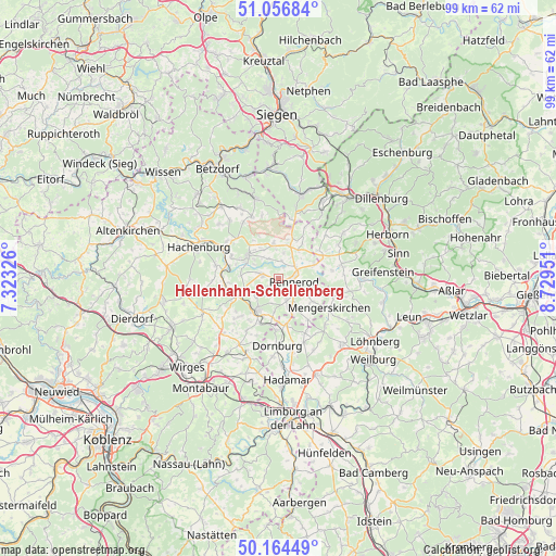
Hellenhahn-Schellenberg GPS coordinates[2]
50° 36' 46.008" North, 8° 1' 35.004" East
| Map corner | latitude | longitude |
|---|---|---|
| Upper-left | 51.05684°, | 7.32326° |
| Center: | 50.61278°, | 8.02639° |
| Lower-right: | 50.16449°, | 8.72951° |
| Map W x H: | 99.2×99.2 km | = 61.6×61.6mi |
| max Lat: | 55.01917° ⇑50.2% North |
| Hellenhahn-Schellenberg: | 50.61278° |
| min Lat: | ⇓49.8% South 47.40724° |
| min Long | Hellenhahn-Sche | max Long |
| 5.92978° | 8.02639° | 14.98853° |
| W 23.3%⇐ | ⇒76.7% E |
Elevation
Elevation of Hellenhahn-Schellenberg is 473 m = 1552 ft, and this is 223.9 m = 735 ft above average elevation for this country.
| Max E: |
1256 m = 4121 ft | 14.5% |
| Hellenhahn-Schellenberg | 473 m 1552 ft | |
| Avg. | 249.1 m = 817 ft | |
Min E: |
-5 m = -16 ft | 85.5% |
See also: Germany elevation on elevation.city.
Geographical zone
Hellenhahn-Schellenberg is located in North temperate zone (between Tropic of Cancer and the Arctic Circle). Distance of this North polar circle is 1773.6 km =1102.1 mi to North.| Distance of | km | miles | from Hellenhahn-Schellenberg |
|---|---|---|---|
| North Pole | 4379.4 | 2721.2 | to North |
| Arctic Circle | 1773.6 | 1102.1 | to North |
| Tropic Cancer | 3021.7 | 1877.6 | to South |
| Equator | 5627.6 | 3496.8 | to South |


Nearby cities:
15 places around Hellenhahn-Schellenberg: (largest is in red/bold)
• Fehl-Ritzhausen
3.9 km =2.4 mi,  335°
335°
• Großseifen
4.8 km =3 mi,  298°
298°
• Halbs
5 km =3.1 mi,  240°
240°
• Hergenroth
4.9 km =3 mi,  227°
227°
• Höhn
3.1 km =1.9 mi,  278°
278°
• Neustadt/Westerwald
2.1 km =1.3 mi,  27°
27°
• Niederroßbach
3.3 km =2.1 mi,  10°
10°
• Oberroßbach
4.7 km =2.9 mi, 11°
• Pottum
2.3 km =1.4 mi, 232°
• Rennerod
2.9 km =1.8 mi,  100°
100°
• Seck
4.3 km =2.7 mi,  157°
157°
• Stockhausen-Illfurth
4.7 km =2.9 mi,  323°
323°
• Waldmühlen
4.3 km =2.7 mi,  139°
139°
• Winnen
4.5 km =2.8 mi,  193°
193°
• Zehnhausen bei Rennerod
4.5 km =2.8 mi, 31°
Sources, notices
• [Note1] Compared only with cities in Germany existing in our database
• [Src1] Map data: © OpenStreetMap contributors (CC-BY-SA)
• [Src2] Other city data from geonames.org with taken over terms of usage.
• [Src3] Geographical zone / Annual Mean Temperature by Robert A. Rohde @ Wikipedia
