Oberstaufen geodata
Oberstaufen (Bavaria) is a populated place; located in Germany in Europe/Berlin (GMT+2) time zone. With population of 7,190 people, there are 2144 cities with bigger population in this country. Compared to other cities in Germany, 99.8% of cities are located further ↑North; 50.5% of cities are located further ←West and 99.1% of cities have lower elevation than Oberstaufen. Note1
Administrative division(s):
- Level 1: Bavaria
- Level 2: Swabia
- Level 3: Landkreis Oberallgäu
- Level 4: Oberstaufen, Markt


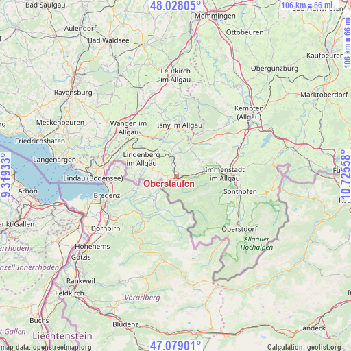
Oberstaufen GPS coordinates[2]
47° 33' 20.448" North, 10° 1' 20.82" East
| Map corner | latitude | longitude |
|---|---|---|
| Upper-left | 48.02805°, | 9.31933° |
| Center: | 47.55568°, | 10.02245° |
| Lower-right: | 47.07901°, | 10.72558° |
| Map W x H: | 105.5×105.5 km | = 65.6×65.6mi |
| max Lat: | 55.01917° ⇑99.8% North |
| Oberstaufen: | 47.55568° |
| min Lat: | ⇓0.2% South 47.40724° |
| min Long | Oberstaufen | max Long |
| 5.92978° | 10.02245° | 14.98853° |
| W 50.5%⇐ | ⇒49.5% E |
Elevation
Elevation of Oberstaufen is 790 m = 2592 ft, and this is 540.9 m = 1775 ft above average elevation for this country.
| Max E: |
1256 m = 4121 ft | 0.90000000000001% |
| Oberstaufen | 790 m 2592 ft | |
| Avg. | 249.1 m = 817 ft | |
Min E: |
-5 m = -16 ft | 99.1% |
See also: Germany elevation on elevation.city.
Geographical zone
Oberstaufen is located in North temperate zone (between Tropic of Cancer and the Arctic Circle). Distance of this North polar circle is 2113.5 km =1313.3 mi to North.| Distance of | km | miles | from Oberstaufen |
|---|---|---|---|
| North Pole | 4719.4 | 2932.5 | to North |
| Arctic Circle | 2113.5 | 1313.3 | to North |
| Tropic Cancer | 2681.8 | 1666.4 | to South |
| Equator | 5287.7 | 3285.6 | to South |


Nearby cities:
15 places around Oberstaufen: (largest is in red/bold)
• Balderschwang
11.5 km =7.1 mi,  149°
149°
• Gestratz
10.9 km =6.8 mi,  344°
344°
• Grünenbach
8.2 km =5.1 mi,  352°
352°
• Heimenkirch
12.2 km =7.6 mi,  312°
312°
• Immenstadt im Allgäu
14.4 km =8.9 mi,  88°
88°
• Isny
15.3 km =9.5 mi,  4°
4°
• Maierhöfen
10.7 km =6.6 mi,  11°
11°
• Missen-Wilhams
8.6 km =5.3 mi,  55°
55°
• Oberreute
5.9 km =3.7 mi,  277°
277°
• Opfenbach
16.6 km =10.3 mi,  301°
301°
• Röthenbach
8.3 km =5.2 mi,  334°
334°
• Scheidegg
13.4 km =8.3 mi, 282°
• Stiefenhofen
4.4 km =2.7 mi, 341°
• Weiler-Simmerberg
8.7 km =5.4 mi,  290°
290°
• Weitnau
12.4 km =7.7 mi,  39°
39°
Sources, notices
• [Note1] Compared only with cities in Germany existing in our database
• [Src1] Map data: © OpenStreetMap contributors (CC-BY-SA)
• [Src2] Other city data from geonames.org with taken over terms of usage.
• [Src3] Geographical zone / Annual Mean Temperature by Robert A. Rohde @ Wikipedia
