Balderschwang geodata
Balderschwang (Bavaria) is a seat of a fourth-order administrative division; located in Germany in Europe/Berlin (GMT+2) time zone. With population of 206 people, there are 10448 cities with bigger population in this country. Compared to other cities in Germany, 100% of cities are located further ↑North; 51.6% of cities are located further ←West and 100% of cities have lower elevation than Balderschwang. Note1
Administrative division(s):
- Level 1: Bavaria
- Level 2: Swabia
- Level 3: Landkreis Oberallgäu
- Level 4: Balderschwang


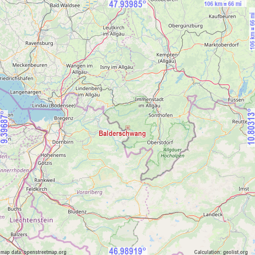
Balderschwang GPS coordinates[2]
47° 28' 0.012" North, 10° 6' 0" East
| Map corner | latitude | longitude |
|---|---|---|
| Upper-left | 47.93985°, | 9.39687° |
| Center: | 47.46667°, | 10.1° |
| Lower-right: | 46.98919°, | 10.80313° |
| Map W x H: | 105.7×105.7 km | = 65.7×65.7mi |
| max Lat: | 55.01917° ⇑100% North |
| Balderschwang: | 47.46667° |
| min Lat: | ⇓0% South 47.40724° |
| min Long | Balderschwang | max Long |
| 5.92978° | 10.1° | 14.98853° |
| W 51.6%⇐ | ⇒48.4% E |
Elevation
Elevation of Balderschwang is 1084 m = 3556 ft, and this is 834.9 m = 2739 ft above average elevation for this country.
| Max E: |
1256 m = 4121 ft | 0% |
| Balderschwang | 1084 m 3556 ft | |
| Avg. | 249.1 m = 817 ft | |
Min E: |
-5 m = -16 ft | 100% |
See also: Germany elevation on elevation.city.
Geographical zone
Balderschwang is located in North temperate zone (between Tropic of Cancer and the Arctic Circle). Distance of this North polar circle is 2123.4 km =1319.4 mi to North.| Distance of | km | miles | from Balderschwang |
|---|---|---|---|
| North Pole | 4729.3 | 2938.6 | to North |
| Arctic Circle | 2123.4 | 1319.4 | to North |
| Tropic Cancer | 2671.9 | 1660.2 | to South |
| Equator | 5277.8 | 3279.5 | to South |


Nearby cities:
15 places around Balderschwang: (largest is in red/bold)
• Blaichach
14.6 km =9.1 mi,  54°
54°
• Bolsterlang
10 km =6.2 mi,  90°
90°
• Burgberg
16.2 km =10.1 mi,  61°
61°
• Grünenbach
19.3 km =12 mi,  339°
339°
• Immenstadt im Allgäu
13.4 km =8.3 mi,  39°
39°
• Missen-Wilhams
14.9 km =9.3 mi,  4°
4°
• Obermaiselstein
10.2 km =6.3 mi,  100°
100°
• Oberreute
15.8 km =9.8 mi,  312°
312°
• Oberstaufen
11.5 km =7.1 mi,  329°
329°
• Oberstdorf
15 km =9.3 mi,  116°
116°
• Ofterschwang
10.7 km =6.6 mi,  69°
69°
• Rettenberg
18.7 km =11.6 mi, 50°
• Sonthofen
14.9 km =9.3 mi, 67°
• Stiefenhofen
15.8 km =9.8 mi, 332°
• Weiler-Simmerberg
19 km =11.8 mi, 312°
Sources, notices
• [Note1] Compared only with cities in Germany existing in our database
• [Src1] Map data: © OpenStreetMap contributors (CC-BY-SA)
• [Src2] Other city data from geonames.org with taken over terms of usage.
• [Src3] Geographical zone / Annual Mean Temperature by Robert A. Rohde @ Wikipedia
