Oberdachstetten geodata
Oberdachstetten (Bavaria) is a seat of a fourth-order administrative division; located in Germany in Europe/Berlin (GMT+2) time zone. With population of 1,720 people, there are 5473 cities with bigger population in this country. Compared to other cities in Germany, 77% of cities are located further ↑North; 57.7% of cities are located further ←West and 86.7% of cities have lower elevation than Oberdachstetten. Note1
Administrative division(s):
- Level 1: Bavaria
- Level 2: Regierungsbezirk Mittelfranken
- Level 3: Landkreis Ansbach
- Level 4: Oberdachstetten


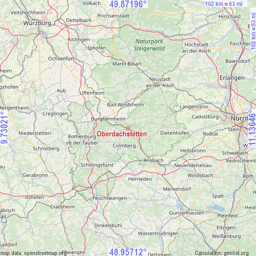
Oberdachstetten GPS coordinates[2]
49° 25' 0.012" North, 10° 25' 59.988" East
| Map corner | latitude | longitude |
|---|---|---|
| Upper-left | 49.87196°, | 9.73021° |
| Center: | 49.41667°, | 10.43333° |
| Lower-right: | 48.95712°, | 11.13646° |
| Map W x H: | 101.7×101.7 km | = 63.2×63.2mi |
| max Lat: | 55.01917° ⇑77% North |
| Oberdachstetten: | 49.41667° |
| min Lat: | ⇓23% South 47.40724° |
| min Long | Oberdachstetten | max Long |
| 5.92978° | 10.43333° | 14.98853° |
| W 57.7%⇐ | ⇒42.3% E |
Elevation
Elevation of Oberdachstetten is 483 m = 1585 ft, and this is 233.9 m = 767 ft above average elevation for this country.
| Max E: |
1256 m = 4121 ft | 13.3% |
| Oberdachstetten | 483 m 1585 ft | |
| Avg. | 249.1 m = 817 ft | |
Min E: |
-5 m = -16 ft | 86.7% |
See also: Germany elevation on elevation.city.
Geographical zone
Oberdachstetten is located in North temperate zone (between Tropic of Cancer and the Arctic Circle). Distance of this North polar circle is 1906.6 km =1184.7 mi to North.| Distance of | km | miles | from Oberdachstetten |
|---|---|---|---|
| North Pole | 4512.4 | 2803.9 | to North |
| Arctic Circle | 1906.6 | 1184.7 | to North |
| Tropic Cancer | 2888.7 | 1795 | to South |
| Equator | 5494.6 | 3414.2 | to South |


Nearby cities:
15 places around Oberdachstetten: (largest is in red/bold)
• Bad Windsheim
9.7 km =6 mi,  352°
352°
• Buch am Wald
12 km =7.5 mi,  216°
216°
• Burgbernheim
8.8 km =5.5 mi,  295°
295°
• Colmberg
7.1 km =4.4 mi,  192°
192°
• Flachslanden
6.1 km =3.8 mi,  109°
109°
• Gallmersgarten
12.6 km =7.8 mi,  287°
287°
• Geslau
10.2 km =6.3 mi,  236°
236°
• Illesheim
8 km =5 mi,  332°
332°
• Ipsheim
12.8 km =8 mi,  15°
15°
• Lehrberg
9.7 km =6 mi,  144°
144°
• Marktbergel
5.8 km =3.6 mi, 298°
• Obernzenn
4.6 km =2.9 mi,  31°
31°
• Rügland
11 km =6.8 mi,  99°
99°
• Trautskirchen
12.5 km =7.8 mi,  68°
68°
• Windelsbach
9.8 km =6.1 mi,  259°
259°
Sources, notices
• [Note1] Compared only with cities in Germany existing in our database
• [Src1] Map data: © OpenStreetMap contributors (CC-BY-SA)
• [Src2] Other city data from geonames.org with taken over terms of usage.
• [Src3] Geographical zone / Annual Mean Temperature by Robert A. Rohde @ Wikipedia
