Berge geodata
Berge (Lower Saxony) is a seat of a fourth-order administrative division; located in Germany in Europe/Berlin (GMT+2) time zone. With population of 3,772 people, there are 3426 cities with bigger population in this country. Compared to other cities in Germany, 79.1% of cities are located further ↓South; 82.2% of cities are located further →East and 81% of cities have higher elevation than Berge. Note1


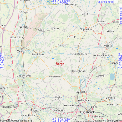
Berge GPS coordinates[2]
52° 37' 23.736" North, 7° 44' 43.8" East
| Map corner | latitude | longitude |
|---|---|---|
| Upper-left | 53.04802°, | 7.04237° |
| Center: | 52.62326°, | 7.7455° |
| Lower-right: | 52.19434°, | 8.44862° |
| Map W x H: | 94.9×94.9 km | = 59×59mi |
| max Lat: | 55.01917° ⇑20.9% North |
| Berge: | 52.62326° |
| min Lat: | ⇓79.1% South 47.40724° |
| min Long | Berge | max Long |
| 5.92978° | 7.7455° | 14.98853° |
| W 17.8%⇐ | ⇒82.2% E |
Elevation
Elevation of Berge is 44 m = 144 ft, and this is 205.1 m = 673 ft below average elevation for this country.
| Max E: |
1256 m = 4121 ft | 81% |
| Avg. | 249.1 m = 817 ft | |
| Berge | 44 m = 144 ft | |
Min E: |
-5 m = -16 ft | 19% |
See also: Germany elevation on elevation.city.
Geographical zone
Berge is located in North temperate zone (between Tropic of Cancer and the Arctic Circle). Distance of this North polar circle is 1550 km =963.1 mi to North.| Distance of | km | miles | from Berge |
|---|---|---|---|
| North Pole | 4155.9 | 2582.4 | to North |
| Arctic Circle | 1550 | 963.1 | to North |
| Tropic Cancer | 3245.2 | 2016.5 | to South |
| Equator | 5851.2 | 3635.8 | to South |


Nearby cities:
15 places around Berge: (largest is in red/bold)
• Ankum
12.4 km =7.7 mi,  131°
131°
• Badbergen
16.1 km =10 mi,  86°
86°
• Bersenbrück
15.9 km =9.9 mi,  120°
120°
• Bippen
4.5 km =2.8 mi,  190°
190°
• Dohren
11.3 km =7 mi,  285°
285°
• Eggermühlen
7.9 km =4.9 mi,  142°
142°
• Fürstenau
12.7 km =7.9 mi,  201°
201°
• Handrup
13.1 km =8.1 mi,  240°
240°
• Herzlake
12 km =7.5 mi,  305°
305°
• Kettenkamp
7.4 km =4.6 mi, 126°
• Löningen
12.7 km =7.9 mi,  3°
3°
• Menslage
8.2 km =5.1 mi,  35°
35°
• Nortrup
7.8 km =4.8 mi,  96°
96°
• Quakenbrück
14.9 km =9.3 mi,  67°
67°
• Wettrup
10.6 km =6.6 mi,  248°
248°
Sources, notices
• [Note1] Compared only with cities in Germany existing in our database
• [Src1] Map data: © OpenStreetMap contributors (CC-BY-SA)
• [Src2] Other city data from geonames.org with taken over terms of usage.
• [Src3] Geographical zone / Annual Mean Temperature by Robert A. Rohde @ Wikipedia
