Bubenheim geodata
Bubenheim (Rheinland-Pfalz) is a seat of a fourth-order administrative division; located in Germany in Europe/Berlin (GMT+2) time zone. With population of 841 people, there are 7739 cities with bigger population in this country. Compared to other cities in Germany, 65.8% of cities are located further ↑North; 75.8% of cities are located further →East and 62.3% of cities have higher elevation than Bubenheim. Note1
Administrative division(s):
- Level 1: Rheinland-Pfalz
- Level 3: Landkreis Mainz-Bingen
- Level 4: Bubenheim


Bubenheim GPS coordinates[2]
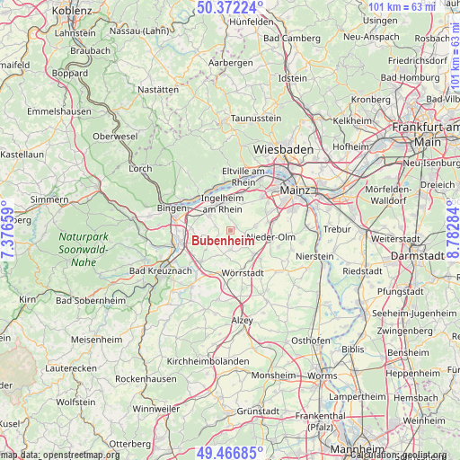
49° 55' 18.012" North, 8° 4' 46.992" East
| Map corner | latitude | longitude |
|---|---|---|
| Upper-left | 50.37224°, | 7.37659° |
| Center: | 49.92167°, | 8.07972° |
| Lower-right: | 49.46685°, | 8.78284° |
| Map W x H: | 100.7×100.7 km | = 62.6×62.6mi |
| max Lat: | 55.01917° ⇑65.8% North |
| Bubenheim: | 49.92167° |
| min Lat: | ⇓34.2% South 47.40724° |
| min Long | Bubenheim | max Long |
| 5.92978° | 8.07972° | 14.98853° |
| W 24.2%⇐ | ⇒75.8% E |
Elevation
Elevation of Bubenheim is 136 m = 446 ft, and this is 113.1 m = 371 ft below average elevation for this country.
| Max E: |
1256 m = 4121 ft | 62.3% |
| Avg. | 249.1 m = 817 ft | |
| Bubenheim | 136 m = 446 ft | |
Min E: |
-5 m = -16 ft | 37.7% |
See also: Germany elevation on elevation.city.
Geographical zone
Bubenheim is located in North temperate zone (between Tropic of Cancer and the Arctic Circle). Distance of this North polar circle is 1850.4 km =1149.8 mi to North.| Distance of | km | miles | from Bubenheim |
|---|---|---|---|
| North Pole | 4456.3 | 2769 | to North |
| Arctic Circle | 1850.4 | 1149.8 | to North |
| Tropic Cancer | 2944.9 | 1829.9 | to South |
| Equator | 5550.8 | 3449.1 | to South |


Nearby cities:
15 places around Bubenheim: (largest is in red/bold)
• Appenheim
3.4 km =2.1 mi,  285°
285°
• Engelstadt
2.2 km =1.4 mi,  207°
207°
• Essenheim
5.5 km =3.4 mi,  79°
79°
• Gau-Algesheim
6 km =3.7 mi,  310°
310°
• Ingelheim am Rhein
5.7 km =3.5 mi,  344°
344°
• Jugenheim
3.1 km =1.9 mi,  173°
173°
• Nieder-Hilbersheim
2.9 km =1.8 mi,  251°
251°
• Nieder-Ingelheim
6.2 km =3.9 mi,  355°
355°
• Ober-Hilbersheim
4.4 km =2.7 mi,  236°
236°
• Partenheim
4.2 km =2.6 mi,  177°
177°
• Schwabenheim
1.4 km =0.9 mi,  54°
54°
• Stadecken-Elsheim
3.4 km =2.1 mi,  107°
107°
• Vendersheim
6.2 km =3.9 mi,  187°
187°
• Wackernheim
6.4 km =4 mi,  24°
24°
• Wolfsheim
6.2 km =3.9 mi, 207°
Sources, notices
• [Note1] Compared only with cities in Germany existing in our database
• [Src1] Map data: © OpenStreetMap contributors (CC-BY-SA)
• [Src2] Other city data from geonames.org with taken over terms of usage.
• [Src3] Geographical zone / Annual Mean Temperature by Robert A. Rohde @ Wikipedia
