Freudenberg geodata
Freudenberg (North Rhine-Westphalia) is a populated place; located in Germany in Europe/Berlin (GMT+2) time zone. With population of 18,601 people, there are 843 cities with bigger population in this country. Compared to other cities in Germany, 56% of cities are located further ↓South; 79.5% of cities are located further →East and 61.2% of cities have lower elevation than Freudenberg. Note1
Administrative division(s):
- Level 1: North Rhine-Westphalia
- Level 2: Regierungsbezirk Arnsberg
- Level 3: Kreis Siegen-Wittgenstein
- Level 4: Freudenberg


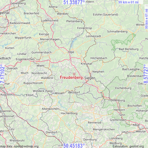
Freudenberg GPS coordinates[2]
50° 53' 50.676" North, 7° 52' 26.94" East
| Map corner | latitude | longitude |
|---|---|---|
| Upper-left | 51.33877°, | 7.17102° |
| Center: | 50.89741°, | 7.87415° |
| Lower-right: | 50.45183°, | 8.57727° |
| Map W x H: | 98.6×98.6 km | = 61.3×61.3mi |
| max Lat: | 55.01917° ⇑44% North |
| Freudenberg: | 50.89741° |
| min Lat: | ⇓56% South 47.40724° |
| min Long | Freudenberg | max Long |
| 5.92978° | 7.87415° | 14.98853° |
| W 20.5%⇐ | ⇒79.5% E |
Elevation
Elevation of Freudenberg is 297 m = 974 ft, and this is 47.9 m = 157 ft above average elevation for this country.
| Max E: |
1256 m = 4121 ft | 38.8% |
| Freudenberg | 297 m 974 ft | |
| Avg. | 249.1 m = 817 ft | |
Min E: |
-5 m = -16 ft | 61.2% |
See also: Germany elevation on elevation.city.
Geographical zone
Freudenberg is located in North temperate zone (between Tropic of Cancer and the Arctic Circle). Distance of this North polar circle is 1741.9 km =1082.4 mi to North.| Distance of | km | miles | from Freudenberg |
|---|---|---|---|
| North Pole | 4347.8 | 2701.6 | to North |
| Arctic Circle | 1741.9 | 1082.4 | to North |
| Tropic Cancer | 3053.3 | 1897.2 | to South |
| Equator | 5659.3 | 3516.5 | to South |


Nearby cities:
15 places around Freudenberg: (largest is in red/bold)
• Betzdorf
11.8 km =7.3 mi,  180°
180°
• Brachbach
9.9 km =6.2 mi,  155°
155°
• Friesenhagen
4.6 km =2.9 mi,  278°
278°
• Grünebach
12.8 km =8 mi,  171°
171°
• Harbach
6 km =3.7 mi,  208°
208°
• Katzwinkel
9.9 km =6.2 mi,  201°
201°
• Kirchen
9.9 km =6.2 mi, 175°
• Kreuztal
11.2 km =7 mi,  45°
45°
• Morsbach
10.8 km =6.7 mi,  251°
251°
• Mudersbach
9.4 km =5.8 mi,  148°
148°
• Niederfischbach
5.3 km =3.3 mi,  185°
185°
• Scheuerfeld
12.5 km =7.8 mi, 190°
• Siegen
10.8 km =6.7 mi,  103°
103°
• Wallmenroth
11.2 km =7 mi, 194°
• Wenden
7.7 km =4.8 mi,  356°
356°
Sources, notices
• [Note1] Compared only with cities in Germany existing in our database
• [Src1] Map data: © OpenStreetMap contributors (CC-BY-SA)
• [Src2] Other city data from geonames.org with taken over terms of usage.
• [Src3] Geographical zone / Annual Mean Temperature by Robert A. Rohde @ Wikipedia
