Niederdorf geodata
Niederdorf (Saxony) is a seat of a fourth-order administrative division; located in Germany in Europe/Berlin (GMT+2) time zone. With population of 1,377 people, there are 6124 cities with bigger population in this country. Compared to other cities in Germany, 52.8% of cities are located further ↓South; 90.6% of cities are located further ←West and 75.7% of cities have lower elevation than Niederdorf. Note1


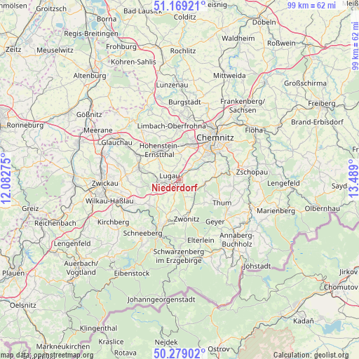
Niederdorf GPS coordinates[2]
50° 43' 34.428" North, 12° 47' 9.132" East
| Map corner | latitude | longitude |
|---|---|---|
| Upper-left | 51.16921°, | 12.08275° |
| Center: | 50.72623°, | 12.78587° |
| Lower-right: | 50.27902°, | 13.489° |
| Map W x H: | 99×99 km | = 61.5×61.5mi |
| max Lat: | 55.01917° ⇑47.2% North |
| Niederdorf: | 50.72623° |
| min Lat: | ⇓52.8% South 47.40724° |
| min Long | Niederdorf | max Long |
| 5.92978° | 12.78587° | 14.98853° |
| W 90.6%⇐ | ⇒9.4% E |
Elevation
Elevation of Niederdorf is 403 m = 1322 ft, and this is 153.9 m = 505 ft above average elevation for this country.
| Max E: |
1256 m = 4121 ft | 24.3% |
| Niederdorf | 403 m 1322 ft | |
| Avg. | 249.1 m = 817 ft | |
Min E: |
-5 m = -16 ft | 75.7% |
See also: Germany elevation on elevation.city.
Geographical zone
Niederdorf is located in North temperate zone (between Tropic of Cancer and the Arctic Circle). Distance of this North polar circle is 1760.9 km =1094.2 mi to North.| Distance of | km | miles | from Niederdorf |
|---|---|---|---|
| North Pole | 4366.8 | 2713.4 | to North |
| Arctic Circle | 1760.9 | 1094.2 | to North |
| Tropic Cancer | 3034.3 | 1885.4 | to South |
| Equator | 5640.2 | 3504.7 | to South |


Nearby cities:
15 places around Niederdorf: (largest is in red/bold)
• Bernsdorf
9.5 km =5.9 mi,  298°
298°
• Burkhardtsdorf
9.2 km =5.7 mi,  85°
85°
• Dorfchemnitz
7.8 km =4.8 mi,  152°
152°
• Gersdorf
5.5 km =3.4 mi, 298°
• Gornsdorf
7.5 km =4.7 mi,  113°
113°
• Hohndorf
7.6 km =4.7 mi,  282°
282°
• Hormersdorf
8.9 km =5.5 mi,  130°
130°
• Jahnsdorf
5.2 km =3.2 mi,  66°
66°
• Kirchberg
4.2 km =2.6 mi,  339°
339°
• Lugau
3 km =1.9 mi, 297°
• Neukirchen
8.3 km =5.2 mi,  44°
44°
• Oberlungwitz
8.3 km =5.2 mi,  318°
318°
• Oelsnitz
6 km =3.7 mi,  269°
269°
• Stollberg
1.8 km =1.1 mi,  192°
192°
• Thalheim
5.3 km =3.3 mi,  122°
122°
Sources, notices
• [Note1] Compared only with cities in Germany existing in our database
• [Src1] Map data: © OpenStreetMap contributors (CC-BY-SA)
• [Src2] Other city data from geonames.org with taken over terms of usage.
• [Src3] Geographical zone / Annual Mean Temperature by Robert A. Rohde @ Wikipedia
