Kirchberg geodata
Kirchberg (Saxony) is a populated place; located in Germany in Europe/Berlin (GMT+2) time zone. With population of 1,838 people, there are 5291 cities with bigger population in this country. Compared to other cities in Germany, 53.5% of cities are located further ↓South; 90.4% of cities are located further ←West and 73.7% of cities have lower elevation than Kirchberg. Note1


Kirchberg GPS coordinates[2]
50° 45' 41.076" North, 12° 45' 53.316" East
| Map corner | latitude | longitude |
|---|---|---|
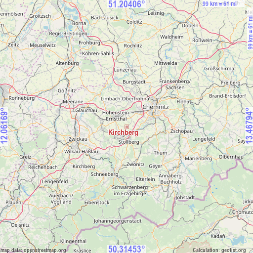
| Upper-left | 51.20406°, | 12.06169° |
| Center: | 50.76141°, | 12.76481° |
| Lower-right: | 50.31453°, | 13.46794° |
| Map W x H: | 98.9×98.9 km | = 61.5×61.5mi |
| max Lat: | 55.01917° ⇑46.5% North |
| Kirchberg: | 50.76141° |
| min Lat: | ⇓53.5% South 47.40724° |
| min Long | Kirchberg | max Long |
| 5.92978° | 12.76481° | 14.98853° |
| W 90.4%⇐ | ⇒9.6% E |
Elevation
Elevation of Kirchberg is 388 m = 1273 ft, and this is 138.9 m = 456 ft above average elevation for this country.
| Max E: |
1256 m = 4121 ft | 26.3% |
| Kirchberg | 388 m 1273 ft | |
| Avg. | 249.1 m = 817 ft | |
Min E: |
-5 m = -16 ft | 73.7% |
See also: Germany elevation on elevation.city.
Geographical zone
Kirchberg is located in North temperate zone (between Tropic of Cancer and the Arctic Circle). Distance of this North polar circle is 1757 km =1091.7 mi to North.| Distance of | km | miles | from Kirchberg |
|---|---|---|---|
| North Pole | 4362.9 | 2711 | to North |
| Arctic Circle | 1757 | 1091.7 | to North |
| Tropic Cancer | 3038.2 | 1887.8 | to South |
| Equator | 5644.1 | 3507.1 | to South |


Nearby cities:
15 places around Kirchberg: (largest is in red/bold)
• Bernsdorf
6.9 km =4.3 mi,  274°
274°
• Gersdorf
3.6 km =2.2 mi,  249°
249°
• Gornsdorf
10.8 km =6.7 mi,  129°
129°
• Hohenstein-Ernstthal
5.7 km =3.5 mi,  320°
320°
• Hohndorf
6.4 km =4 mi, 248°
• Jahnsdorf
6.5 km =4 mi,  106°
106°
• Lichtenstein
9.5 km =5.9 mi, 266°
• Lugau
2.8 km =1.7 mi,  204°
204°
• Neukirchen
7.5 km =4.7 mi,  74°
74°
• Niederdorf
4.2 km =2.6 mi,  159°
159°
• Oberlungwitz
4.6 km =2.9 mi,  300°
300°
• Oelsnitz
6 km =3.7 mi,  228°
228°
• Sankt Egidien
10.3 km =6.4 mi,  285°
285°
• Stollberg
5.8 km =3.6 mi,  169°
169°
• Thalheim
9 km =5.6 mi,  138°
138°
Sources, notices
• [Note1] Compared only with cities in Germany existing in our database
• [Src1] Map data: © OpenStreetMap contributors (CC-BY-SA)
• [Src2] Other city data from geonames.org with taken over terms of usage.
• [Src3] Geographical zone / Annual Mean Temperature by Robert A. Rohde @ Wikipedia
