Thalheim geodata
Thalheim (Saxony) is a populated place; located in Germany in Europe/Berlin (GMT+2) time zone. With population of 7,583 people, there are 2048 cities with bigger population in this country. Compared to other cities in Germany, 52.2% of cities are located further ↓South; 91.1% of cities are located further ←West and 81.4% of cities have lower elevation than Thalheim. Note1


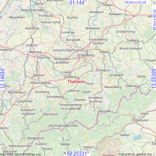
Thalheim GPS coordinates[2]
50° 42' 2.772" North, 12° 50' 59.856" East
| Map corner | latitude | longitude |
|---|---|---|
| Upper-left | 51.144°, | 12.14684° |
| Center: | 50.70077°, | 12.84996° |
| Lower-right: | 50.25331°, | 13.55309° |
| Map W x H: | 99×99 km | = 61.5×61.5mi |
| max Lat: | 55.01917° ⇑47.8% North |
| Thalheim: | 50.70077° |
| min Lat: | ⇓52.2% South 47.40724° |
| min Long | Thalheim | max Long |
| 5.92978° | 12.84996° | 14.98853° |
| W 91.1%⇐ | ⇒8.9% E |
Elevation
Elevation of Thalheim is 443 m = 1453 ft, and this is 193.9 m = 636 ft above average elevation for this country.
| Max E: |
1256 m = 4121 ft | 18.6% |
| Thalheim | 443 m 1453 ft | |
| Avg. | 249.1 m = 817 ft | |
Min E: |
-5 m = -16 ft | 81.4% |
See also: Germany elevation on elevation.city.
Geographical zone
Thalheim is located in North temperate zone (between Tropic of Cancer and the Arctic Circle). Distance of this North polar circle is 1763.8 km =1096 mi to North.| Distance of | km | miles | from Thalheim |
|---|---|---|---|
| North Pole | 4369.7 | 2715.2 | to North |
| Arctic Circle | 1763.8 | 1096 | to North |
| Tropic Cancer | 3031.5 | 1883.7 | to South |
| Equator | 5637.4 | 3502.9 | to South |


Nearby cities:
15 places around Thalheim: (largest is in red/bold)
• Auerbach
5.1 km =3.2 mi,  112°
112°
• Burkhardtsdorf
5.9 km =3.7 mi,  52°
52°
• Dorfchemnitz
4.2 km =2.6 mi,  192°
192°
• Gelenau
8.3 km =5.2 mi,  81°
81°
• Geyer
9.7 km =6 mi,  148°
148°
• Gornsdorf
2.4 km =1.5 mi,  92°
92°
• Hormersdorf
3.7 km =2.3 mi,  142°
142°
• Jahnsdorf
4.9 km =3 mi,  3°
3°
• Kirchberg
9 km =5.6 mi,  318°
318°
• Lugau
8.3 km =5.2 mi,  300°
300°
• Neukirchen
8.8 km =5.5 mi,  8°
8°
• Niederdorf
5.3 km =3.3 mi, 302°
• Stollberg
5 km =3.1 mi,  281°
281°
• Thum
7.9 km =4.9 mi,  115°
115°
• Zwönitz
8.3 km =5.2 mi,  199°
199°
Sources, notices
• [Note1] Compared only with cities in Germany existing in our database
• [Src1] Map data: © OpenStreetMap contributors (CC-BY-SA)
• [Src2] Other city data from geonames.org with taken over terms of usage.
• [Src3] Geographical zone / Annual Mean Temperature by Robert A. Rohde @ Wikipedia
