Neukirchen geodata
Neukirchen (Saxony) is a populated place; located in Germany in Europe/Berlin (GMT+2) time zone. With population of 7,517 people, there are 2065 cities with bigger population in this country. Compared to other cities in Germany, 53.8% of cities are located further ↓South; 91.2% of cities are located further ←West and 69.4% of cities have lower elevation than Neukirchen. Note1


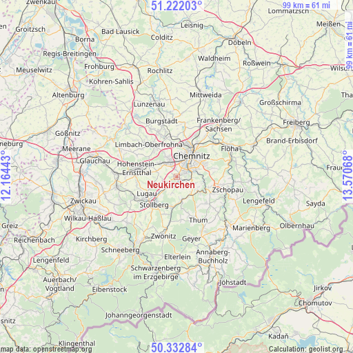
Neukirchen GPS coordinates[2]
50° 46' 46.38" North, 12° 52' 3.18" East
| Map corner | latitude | longitude |
|---|---|---|
| Upper-left | 51.22203°, | 12.16443° |
| Center: | 50.77955°, | 12.86755° |
| Lower-right: | 50.33284°, | 13.57068° |
| Map W x H: | 98.9×98.9 km | = 61.5×61.5mi |
| max Lat: | 55.01917° ⇑46.2% North |
| Neukirchen: | 50.77955° |
| min Lat: | ⇓53.8% South 47.40724° |
| min Long | Neukirchen | max Long |
| 5.92978° | 12.86755° | 14.98853° |
| W 91.2%⇐ | ⇒8.8% E |
Elevation
Elevation of Neukirchen is 354 m = 1161 ft, and this is 104.9 m = 344 ft above average elevation for this country.
| Max E: |
1256 m = 4121 ft | 30.6% |
| Neukirchen | 354 m 1161 ft | |
| Avg. | 249.1 m = 817 ft | |
Min E: |
-5 m = -16 ft | 69.4% |
See also: Germany elevation on elevation.city.
Geographical zone
Neukirchen is located in North temperate zone (between Tropic of Cancer and the Arctic Circle). Distance of this North polar circle is 1755 km =1090.5 mi to North.| Distance of | km | miles | from Neukirchen |
|---|---|---|---|
| North Pole | 4360.9 | 2709.7 | to North |
| Arctic Circle | 1755 | 1090.5 | to North |
| Tropic Cancer | 3040.2 | 1889.1 | to South |
| Equator | 5646.2 | 3508.4 | to South |


Nearby cities:
15 places around Neukirchen: (largest is in red/bold)
• Auerbach
11.2 km =7 mi,  162°
162°
• Burkhardtsdorf
6.2 km =3.9 mi,  146°
146°
• Chemnitz
7.6 km =4.7 mi,  34°
34°
• Gelenau
10.3 km =6.4 mi,  137°
137°
• Gersdorf
11.1 km =6.9 mi,  252°
252°
• Gornsdorf
8.9 km =5.5 mi,  172°
172°
• Hilbersdorf
10 km =6.2 mi, 34°
• Hohenstein-Ernstthal
11.1 km =6.9 mi,  282°
282°
• Jahnsdorf
3.9 km =2.4 mi,  193°
193°
• Kirchberg
7.5 km =4.7 mi, 254°
• Lugau
9.5 km =5.9 mi,  241°
241°
• Niederdorf
8.3 km =5.2 mi,  224°
224°
• Oberlungwitz
11.2 km =7 mi,  271°
271°
• Stollberg
9.9 km =6.2 mi, 218°
• Thalheim
8.8 km =5.5 mi, 188°
Sources, notices
• [Note1] Compared only with cities in Germany existing in our database
• [Src1] Map data: © OpenStreetMap contributors (CC-BY-SA)
• [Src2] Other city data from geonames.org with taken over terms of usage.
• [Src3] Geographical zone / Annual Mean Temperature by Robert A. Rohde @ Wikipedia
