Hohndorf geodata
Hohndorf (Saxony) is a seat of a fourth-order administrative division; located in Germany in Europe/Berlin (GMT+2) time zone. With population of 3,976 people, there are 3316 cities with bigger population in this country. Compared to other cities in Germany, 53.1% of cities are located further ↓South; 89.6% of cities are located further ←West and 72.4% of cities have lower elevation than Hohndorf. Note1


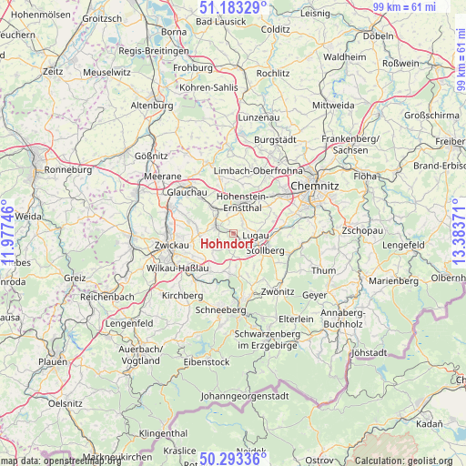
Hohndorf GPS coordinates[2]
50° 44' 25.584" North, 12° 40' 50.088" East
| Map corner | latitude | longitude |
|---|---|---|
| Upper-left | 51.18329°, | 11.97746° |
| Center: | 50.74044°, | 12.68058° |
| Lower-right: | 50.29336°, | 13.38371° |
| Map W x H: | 99×98.9 km | = 61.5×61.5mi |
| max Lat: | 55.01917° ⇑46.9% North |
| Hohndorf: | 50.74044° |
| min Lat: | ⇓53.1% South 47.40724° |
| min Long | Hohndorf | max Long |
| 5.92978° | 12.68058° | 14.98853° |
| W 89.6%⇐ | ⇒10.4% E |
Elevation
Elevation of Hohndorf is 377 m = 1237 ft, and this is 127.9 m = 420 ft above average elevation for this country.
| Max E: |
1256 m = 4121 ft | 27.6% |
| Hohndorf | 377 m 1237 ft | |
| Avg. | 249.1 m = 817 ft | |
Min E: |
-5 m = -16 ft | 72.4% |
See also: Germany elevation on elevation.city.
Geographical zone
Hohndorf is located in North temperate zone (between Tropic of Cancer and the Arctic Circle). Distance of this North polar circle is 1759.4 km =1093.2 mi to North.| Distance of | km | miles | from Hohndorf |
|---|---|---|---|
| North Pole | 4365.3 | 2712.5 | to North |
| Arctic Circle | 1759.4 | 1093.2 | to North |
| Tropic Cancer | 3035.9 | 1886.4 | to South |
| Equator | 5641.8 | 3505.7 | to South |


Nearby cities:
15 places around Hohndorf: (largest is in red/bold)
• Bernsdorf
3.1 km =1.9 mi,  341°
341°
• Gersdorf
2.8 km =1.7 mi,  67°
67°
• Hartenstein
8.7 km =5.4 mi,  185°
185°
• Hohenstein-Ernstthal
7.1 km =4.4 mi,  18°
18°
• Kirchberg
6.4 km =4 mi, 68°
• Lichtenstein
4 km =2.5 mi,  296°
296°
• Lugau
4.8 km =3 mi,  92°
92°
• Mülsen
8.1 km =5 mi,  277°
277°
• Niederdorf
7.6 km =4.7 mi,  102°
102°
• Oberlungwitz
5 km =3.1 mi, 22°
• Oelsnitz
2.2 km =1.4 mi,  138°
138°
• Reinsdorf
10 km =6.2 mi,  241°
241°
• Sankt Egidien
6.5 km =4 mi,  321°
321°
• Stollberg
7.8 km =4.8 mi,  115°
115°
• Wildenfels
9.5 km =5.9 mi,  212°
212°
Sources, notices
• [Note1] Compared only with cities in Germany existing in our database
• [Src1] Map data: © OpenStreetMap contributors (CC-BY-SA)
• [Src2] Other city data from geonames.org with taken over terms of usage.
• [Src3] Geographical zone / Annual Mean Temperature by Robert A. Rohde @ Wikipedia
