Oberlungwitz geodata
Oberlungwitz (Saxony) is a populated place; located in Germany in Europe/Berlin (GMT+2) time zone. With population of 6,794 people, there are 2236 cities with bigger population in this country. Compared to other cities in Germany, 53.8% of cities are located further ↓South; 89.8% of cities are located further ←West and 61.7% of cities have lower elevation than Oberlungwitz. Note1


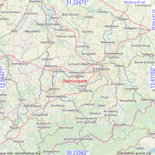
Oberlungwitz GPS coordinates[2]
50° 46' 56.28" North, 12° 42' 28.404" East
| Map corner | latitude | longitude |
|---|---|---|
| Upper-left | 51.22475°, | 12.00477° |
| Center: | 50.7823°, | 12.70789° |
| Lower-right: | 50.33562°, | 13.41102° |
| Map W x H: | 98.9×98.9 km | = 61.5×61.5mi |
| max Lat: | 55.01917° ⇑46.2% North |
| Oberlungwitz: | 50.7823° |
| min Lat: | ⇓53.8% South 47.40724° |
| min Long | Oberlungwitz | max Long |
| 5.92978° | 12.70789° | 14.98853° |
| W 89.8%⇐ | ⇒10.2% E |
Elevation
Elevation of Oberlungwitz is 300 m = 984 ft, and this is 50.9 m = 167 ft above average elevation for this country.
| Max E: |
1256 m = 4121 ft | 38.3% |
| Oberlungwitz | 300 m 984 ft | |
| Avg. | 249.1 m = 817 ft | |
Min E: |
-5 m = -16 ft | 61.7% |
See also: Germany elevation on elevation.city.
Geographical zone
Oberlungwitz is located in North temperate zone (between Tropic of Cancer and the Arctic Circle). Distance of this North polar circle is 1754.7 km =1090.3 mi to North.| Distance of | km | miles | from Oberlungwitz |
|---|---|---|---|
| North Pole | 4360.6 | 2709.6 | to North |
| Arctic Circle | 1754.7 | 1090.3 | to North |
| Tropic Cancer | 3040.5 | 1889.3 | to South |
| Equator | 5646.5 | 3508.6 | to South |


Nearby cities:
15 places around Oberlungwitz: (largest is in red/bold)
• Bernsdorf
3.4 km =2.1 mi,  239°
239°
• Callenberg
9.2 km =5.7 mi,  325°
325°
• Gersdorf
3.6 km =2.2 mi,  170°
170°
• Hohenstein-Ernstthal
2.1 km =1.3 mi,  9°
9°
• Hohndorf
5 km =3.1 mi,  202°
202°
• Jahnsdorf
11.1 km =6.9 mi,  111°
111°
• Kirchberg
4.6 km =2.9 mi,  120°
120°
• Lichtenstein
6.2 km =3.9 mi, 242°
• Limbach-Oberfrohna
9.3 km =5.8 mi,  23°
23°
• Lugau
5.7 km =3.5 mi,  149°
149°
• Mülsen
10.6 km =6.6 mi,  250°
250°
• Niederdorf
8.3 km =5.2 mi,  138°
138°
• Oelsnitz
6.3 km =3.9 mi,  184°
184°
• Sankt Egidien
5.9 km =3.7 mi,  274°
274°
• Stollberg
9.5 km =5.9 mi, 147°
Sources, notices
• [Note1] Compared only with cities in Germany existing in our database
• [Src1] Map data: © OpenStreetMap contributors (CC-BY-SA)
• [Src2] Other city data from geonames.org with taken over terms of usage.
• [Src3] Geographical zone / Annual Mean Temperature by Robert A. Rohde @ Wikipedia
