Neukirchen geodata
Neukirchen (Bavaria) is a populated place; located in Germany in Europe/Berlin (GMT+2) time zone. With population of 4,071 people, there are 3259 cities with bigger population in this country. Compared to other cities in Germany, 79.4% of cities are located further ↑North; 92.1% of cities are located further ←West and 88.1% of cities have lower elevation than Neukirchen. Note1
Administrative division(s):
- Level 1: Bavaria
- Level 2: Upper Palatinate
- Level 3: Landkreis Cham
- Level 4: Neukirchen b.Hl.Blut, Markt


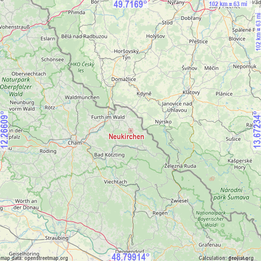
Neukirchen GPS coordinates[2]
49° 15' 36.54" North, 12° 58' 9.156" East
| Map corner | latitude | longitude |
|---|---|---|
| Upper-left | 49.7169°, | 12.26609° |
| Center: | 49.26015°, | 12.96921° |
| Lower-right: | 48.79914°, | 13.67234° |
| Map W x H: | 102×102 km | = 63.4×63.4mi |
| max Lat: | 55.01917° ⇑79.4% North |
| Neukirchen: | 49.26015° |
| min Lat: | ⇓20.6% South 47.40724° |
| min Long | Neukirchen | max Long |
| 5.92978° | 12.96921° | 14.98853° |
| W 92.1%⇐ | ⇒7.9% E |
Elevation
Elevation of Neukirchen is 495 m = 1624 ft, and this is 245.9 m = 807 ft above average elevation for this country.
| Max E: |
1256 m = 4121 ft | 11.9% |
| Neukirchen | 495 m 1624 ft | |
| Avg. | 249.1 m = 817 ft | |
Min E: |
-5 m = -16 ft | 88.1% |
See also: Germany elevation on elevation.city.
Geographical zone
Neukirchen is located in North temperate zone (between Tropic of Cancer and the Arctic Circle). Distance of this North polar circle is 1924 km =1195.5 mi to North.| Distance of | km | miles | from Neukirchen |
|---|---|---|---|
| North Pole | 4529.8 | 2814.7 | to North |
| Arctic Circle | 1924 | 1195.5 | to North |
| Tropic Cancer | 2871.3 | 1784.1 | to South |
| Equator | 5477.2 | 3403.4 | to South |


Nearby cities:
15 places around Neukirchen: (largest is in red/bold)
• Arnbruck
14.6 km =9.1 mi,  171°
171°
• Arnschwang
11.3 km =7 mi,  279°
279°
• Arrach
7.8 km =4.8 mi, 166°
• Blaibach
15.2 km =9.4 mi,  226°
226°
• Drachselsried
17.2 km =10.7 mi, 169°
• Eschlkam
5.8 km =3.6 mi,  317°
317°
• Furth im Wald
10.8 km =6.7 mi,  300°
300°
• Grafenwiesen
9.1 km =5.7 mi,  222°
222°
• Hohenwarth
7.2 km =4.5 mi,  201°
201°
• Kötzting
12.5 km =7.8 mi, 221°
• Lam
9.2 km =5.7 mi,  140°
140°
• Lohberg
13.6 km =8.5 mi,  133°
133°
• Rimbach
6.9 km =4.3 mi,  244°
244°
• Runding
15.8 km =9.8 mi,  251°
251°
• Weiding
15 km =9.3 mi,  271°
271°
Sources, notices
• [Note1] Compared only with cities in Germany existing in our database
• [Src1] Map data: © OpenStreetMap contributors (CC-BY-SA)
• [Src2] Other city data from geonames.org with taken over terms of usage.
• [Src3] Geographical zone / Annual Mean Temperature by Robert A. Rohde @ Wikipedia
