Pressig geodata
Pressig (Bavaria) is a populated place; located in Germany in Europe/Berlin (GMT+2) time zone. With population of 4,277 people, there are 3145 cities with bigger population in this country. Compared to other cities in Germany, 55.5% of cities are located further ↑North; 71.4% of cities are located further ←West and 74.3% of cities have lower elevation than Pressig. Note1
Administrative division(s):
- Level 1: Bavaria
- Level 2: Upper Franconia
- Level 3: Landkreis Kronach
- Level 4: Pressig, Markt


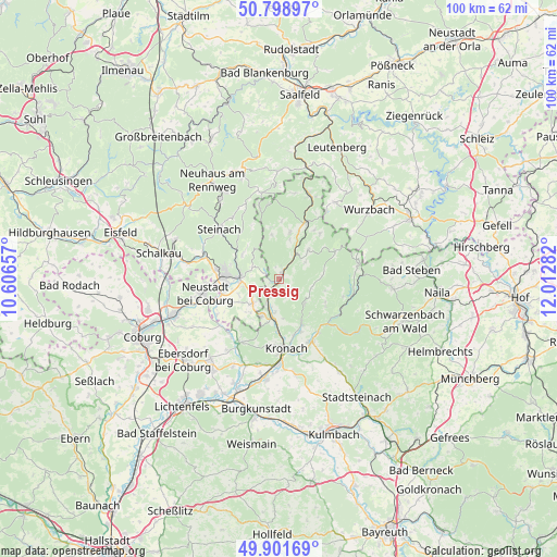
Pressig GPS coordinates[2]
50° 21' 8.82" North, 11° 18' 34.884" East
| Map corner | latitude | longitude |
|---|---|---|
| Upper-left | 50.79897°, | 10.60657° |
| Center: | 50.35245°, | 11.30969° |
| Lower-right: | 49.90169°, | 12.01282° |
| Map W x H: | 99.8×99.8 km | = 62×62mi |
| max Lat: | 55.01917° ⇑55.5% North |
| Pressig: | 50.35245° |
| min Lat: | ⇓44.5% South 47.40724° |
| min Long | Pressig | max Long |
| 5.92978° | 11.30969° | 14.98853° |
| W 71.4%⇐ | ⇒28.6% E |
Elevation
Elevation of Pressig is 392 m = 1286 ft, and this is 142.9 m = 469 ft above average elevation for this country.
| Max E: |
1256 m = 4121 ft | 25.7% |
| Pressig | 392 m 1286 ft | |
| Avg. | 249.1 m = 817 ft | |
Min E: |
-5 m = -16 ft | 74.3% |
See also: Germany elevation on elevation.city.
Geographical zone
Pressig is located in North temperate zone (between Tropic of Cancer and the Arctic Circle). Distance of this North polar circle is 1802.5 km =1120 mi to North.| Distance of | km | miles | from Pressig |
|---|---|---|---|
| North Pole | 4408.4 | 2739.3 | to North |
| Arctic Circle | 1802.5 | 1120 | to North |
| Tropic Cancer | 2992.7 | 1859.6 | to South |
| Equator | 5598.7 | 3478.9 | to South |


Nearby cities:
15 places around Pressig: (largest is in red/bold)
• Ebersdorf
11.4 km =7.1 mi,  256°
256°
• Föritz
5.7 km =3.5 mi, 257°
• Judenbach
7.9 km =4.9 mi,  307°
307°
• Kronach
12.7 km =7.9 mi,  172°
172°
• Marktrodach
12.5 km =7.8 mi,  155°
155°
• Mitwitz
13.4 km =8.3 mi,  212°
212°
• Neuhaus-Schierschnitz
6.6 km =4.1 mi,  227°
227°
• Reichenbach
10.8 km =6.7 mi,  42°
42°
• Sonneberg
9.6 km =6 mi,  274°
274°
• Steinwiesen
12.6 km =7.8 mi,  120°
120°
• Stockheim
5.5 km =3.4 mi,  201°
201°
• Tettau
13.5 km =8.4 mi,  344°
344°
• Teuschnitz
7.3 km =4.5 mi,  45°
45°
• Tschirn
11.3 km =7 mi,  62°
62°
• Wilhelmsthal
6.4 km =4 mi,  135°
135°
Sources, notices
• [Note1] Compared only with cities in Germany existing in our database
• [Src1] Map data: © OpenStreetMap contributors (CC-BY-SA)
• [Src2] Other city data from geonames.org with taken over terms of usage.
• [Src3] Geographical zone / Annual Mean Temperature by Robert A. Rohde @ Wikipedia
