Sonneberg geodata
Sonneberg (Thuringia) is a seat of a third-order administrative division; located in Germany in Europe/Berlin (GMT+2) time zone. With population of 23,908 people, there are 627 cities with bigger population in this country. Compared to other cities in Germany, 55.4% of cities are located further ↑North; 69.6% of cities are located further ←West and 75.1% of cities have lower elevation than Sonneberg. Note1


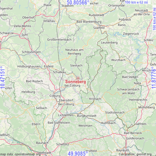
Sonneberg GPS coordinates[2]
50° 21' 33.12" North, 11° 10' 28.668" East
| Map corner | latitude | longitude |
|---|---|---|
| Upper-left | 50.80566°, | 10.47151° |
| Center: | 50.3592°, | 11.17463° |
| Lower-right: | 49.9085°, | 11.87776° |
| Map W x H: | 99.8×99.8 km | = 62×62mi |
| max Lat: | 55.01917° ⇑55.4% North |
| Sonneberg: | 50.3592° |
| min Lat: | ⇓44.6% South 47.40724° |
| min Long | Sonneberg | max Long |
| 5.92978° | 11.17463° | 14.98853° |
| W 69.6%⇐ | ⇒30.4% E |
Elevation
Elevation of Sonneberg is 398 m = 1306 ft, and this is 148.9 m = 489 ft above average elevation for this country.
| Max E: |
1256 m = 4121 ft | 24.9% |
| Sonneberg | 398 m 1306 ft | |
| Avg. | 249.1 m = 817 ft | |
Min E: |
-5 m = -16 ft | 75.1% |
See also: Germany elevation on elevation.city.
Geographical zone
Sonneberg is located in North temperate zone (between Tropic of Cancer and the Arctic Circle). Distance of this North polar circle is 1801.8 km =1119.6 mi to North.| Distance of | km | miles | from Sonneberg |
|---|---|---|---|
| North Pole | 4407.6 | 2738.8 | to North |
| Arctic Circle | 1801.8 | 1119.6 | to North |
| Tropic Cancer | 2993.5 | 1860.1 | to South |
| Equator | 5599.4 | 3479.3 | to South |


Nearby cities:
15 places around Sonneberg: (largest is in red/bold)
• Ebersdorf
3.7 km =2.3 mi,  204°
204°
• Föritz
4.5 km =2.8 mi,  115°
115°
• Judenbach
5.2 km =3.2 mi,  38°
38°
• Lauscha
13.1 km =8.1 mi,  355°
355°
• Mengersgereuth-Hämmern
5.9 km =3.7 mi,  315°
315°
• Mitwitz
12.3 km =7.6 mi,  168°
168°
• Neuhaus-Schierschnitz
7 km =4.3 mi,  138°
138°
• Neustadt bei Coburg
5 km =3.1 mi,  229°
229°
• Pressig
9.6 km =6 mi,  94°
94°
• Rödental
11.8 km =7.3 mi, 233°
• Schalkau
12.5 km =7.8 mi,  288°
288°
• Steinach
8.1 km =5 mi,  352°
352°
• Steinheid
13.5 km =8.4 mi,  331°
331°
• Stockheim
9.6 km =6 mi,  127°
127°
• Tettau
13.7 km =8.5 mi,  25°
25°
Sources, notices
• [Note1] Compared only with cities in Germany existing in our database
• [Src1] Map data: © OpenStreetMap contributors (CC-BY-SA)
• [Src2] Other city data from geonames.org with taken over terms of usage.
• [Src3] Geographical zone / Annual Mean Temperature by Robert A. Rohde @ Wikipedia
