Bastorf geodata
Bastorf (Mecklenburg-Vorpommern) is a populated place; located in Germany in Europe/Berlin (GMT+2) time zone. With population of 1,128 people, there are 6770 cities with bigger population in this country. Compared to other cities in Germany, 94.2% of cities are located further ↓South; 77.2% of cities are located further ←West and 74.3% of cities have higher elevation than Bastorf. Note1
Administrative division(s):
- Level 1: Mecklenburg-Vorpommern
- Level 3: Landkreis Rostock
- Level 4: Bastorf


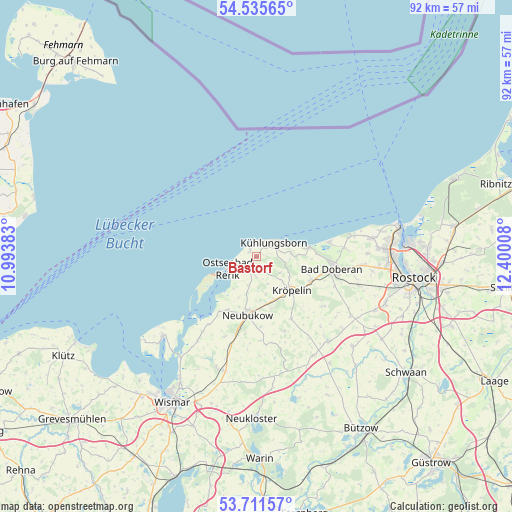
Bastorf GPS coordinates[2]
54° 7' 32.376" North, 11° 41' 49.02" East
| Map corner | latitude | longitude |
|---|---|---|
| Upper-left | 54.53565°, | 10.99383° |
| Center: | 54.12566°, | 11.69695° |
| Lower-right: | 53.71157°, | 12.40008° |
| Map W x H: | 91.6×91.6 km | = 56.9×56.9mi |
| max Lat: | 55.01917° ⇑5.8% North |
| Bastorf: | 54.12566° |
| min Lat: | ⇓94.2% South 47.40724° |
| min Long | Bastorf | max Long |
| 5.92978° | 11.69695° | 14.98853° |
| W 77.2%⇐ | ⇒22.8% E |
Elevation
Elevation of Bastorf is 66 m = 217 ft, and this is 183.1 m = 601 ft below average elevation for this country.
| Max E: |
1256 m = 4121 ft | 74.3% |
| Avg. | 249.1 m = 817 ft | |
| Bastorf | 66 m = 217 ft | |
Min E: |
-5 m = -16 ft | 25.7% |
See also: Germany elevation on elevation.city.
Geographical zone
Bastorf is located in North temperate zone (between Tropic of Cancer and the Arctic Circle). Distance of this North polar circle is 1383 km =859.4 mi to North.| Distance of | km | miles | from Bastorf |
|---|---|---|---|
| North Pole | 3988.9 | 2478.6 | to North |
| Arctic Circle | 1383 | 859.4 | to North |
| Tropic Cancer | 3412.3 | 2120.3 | to South |
| Equator | 6018.2 | 3739.5 | to South |


Nearby cities:
15 places around Bastorf: (largest is in red/bold)
• Alt Bukow
15.4 km =9.6 mi,  202°
202°
• Bad Doberan
13.4 km =8.3 mi,  98°
98°
• Biendorf
5.6 km =3.5 mi,  177°
177°
• Blowatz
18.5 km =11.5 mi,  215°
215°
• Boiensdorf
15 km =9.3 mi, 216°
• Börgerende-Rethwisch
15 km =9.3 mi,  83°
83°
• Güstow
15.7 km =9.8 mi, 216°
• Jennewitz
7 km =4.3 mi,  120°
120°
• Kröpelin
8.9 km =5.5 mi,  134°
134°
• Neubukow
10.5 km =6.5 mi,  188°
188°
• Ostseebad Kühlungsborn
4.9 km =3 mi,  56°
56°
• Reddelich
10.8 km =6.7 mi,  112°
112°
• Retschow
14.8 km =9.2 mi, 127°
• Steffenshagen
8.5 km =5.3 mi, 105°
• Wittenbeck
5.9 km =3.7 mi,  93°
93°
Sources, notices
• [Note1] Compared only with cities in Germany existing in our database
• [Src1] Map data: © OpenStreetMap contributors (CC-BY-SA)
• [Src2] Other city data from geonames.org with taken over terms of usage.
• [Src3] Geographical zone / Annual Mean Temperature by Robert A. Rohde @ Wikipedia
