Neckarsulm geodata
Neckarsulm (Baden-Württemberg) is a populated place; located in Germany in Europe/Berlin (GMT+2) time zone. With population of 27,413 people, there are 525 cities with bigger population in this country. Compared to other cities in Germany, 80.5% of cities are located further ↑North; 61.9% of cities are located further →East and 57% of cities have higher elevation than Neckarsulm. Note1
Administrative division(s):
- Level 1: Baden-Württemberg
- Level 2: Regierungsbezirk Stuttgart
- Level 3: Landkreis Heilbronn
- Level 4: Neckarsulm


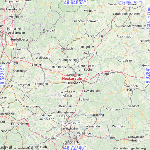
Neckarsulm GPS coordinates[2]
49° 11' 20.832" North, 9° 13' 30.972" East
| Map corner | latitude | longitude |
|---|---|---|
| Upper-left | 49.64653°, | 8.52215° |
| Center: | 49.18912°, | 9.22527° |
| Lower-right: | 48.72745°, | 9.9284° |
| Map W x H: | 102.2×102.2 km | = 63.5×63.5mi |
| max Lat: | 55.01917° ⇑80.5% North |
| Neckarsulm: | 49.18912° |
| min Lat: | ⇓19.5% South 47.40724° |
| min Long | Neckarsulm | max Long |
| 5.92978° | 9.22527° | 14.98853° |
| W 38.1%⇐ | ⇒61.9% E |
Elevation
Elevation of Neckarsulm is 174 m = 571 ft, and this is 75.1 m = 246 ft below average elevation for this country.
| Max E: |
1256 m = 4121 ft | 57% |
| Avg. | 249.1 m = 817 ft | |
| Neckarsulm | 174 m = 571 ft | |
Min E: |
-5 m = -16 ft | 43% |
See also: Germany elevation on elevation.city.
Geographical zone
Neckarsulm is located in North temperate zone (between Tropic of Cancer and the Arctic Circle). Distance of this North polar circle is 1931.9 km =1200.4 mi to North.| Distance of | km | miles | from Neckarsulm |
|---|---|---|---|
| North Pole | 4537.7 | 2819.6 | to North |
| Arctic Circle | 1931.9 | 1200.4 | to North |
| Tropic Cancer | 2863.4 | 1779.2 | to South |
| Equator | 5469.3 | 3398.5 | to South |


Nearby cities:
15 places around Neckarsulm: (largest is in red/bold)
• Bad Rappenau
10.5 km =6.5 mi,  301°
301°
• Bad Wimpfen
6.7 km =4.2 mi,  312°
312°
• Eberstadt
7 km =4.3 mi,  98°
98°
• Ellhofen
8.5 km =5.3 mi,  123°
123°
• Erlenbach
3.6 km =2.2 mi, 120°
• Flein
9.6 km =6 mi,  186°
186°
• Heilbronn
5.5 km =3.4 mi,  183°
183°
• Lehrensteinsfeld
9.8 km =6.1 mi,  131°
131°
• Leingarten
9.2 km =5.7 mi,  238°
238°
• Neuenstadt am Kocher
9.3 km =5.8 mi,  56°
56°
• Nordheim
11.4 km =7.1 mi,  218°
218°
• Oedheim
6 km =3.7 mi,  19°
19°
• Offenau
7.9 km =4.9 mi,  323°
323°
• Untereisesheim
3 km =1.9 mi,  325°
325°
• Weinsberg
6.2 km =3.9 mi, 132°
Sources, notices
• [Note1] Compared only with cities in Germany existing in our database
• [Src1] Map data: © OpenStreetMap contributors (CC-BY-SA)
• [Src2] Other city data from geonames.org with taken over terms of usage.
• [Src3] Geographical zone / Annual Mean Temperature by Robert A. Rohde @ Wikipedia
