Lehrensteinsfeld geodata
Lehrensteinsfeld (Baden-Württemberg) is a seat of a fourth-order administrative division; located in Germany in Europe/Berlin (GMT+2) time zone. With population of 1,986 people, there are 5091 cities with bigger population in this country. Compared to other cities in Germany, 81.4% of cities are located further ↑North; 60.4% of cities are located further →East and 53% of cities have higher elevation than Lehrensteinsfeld. Note1
Administrative division(s):
- Level 1: Baden-Württemberg
- Level 2: Regierungsbezirk Stuttgart
- Level 3: Landkreis Heilbronn
- Level 4: Lehrensteinsfeld


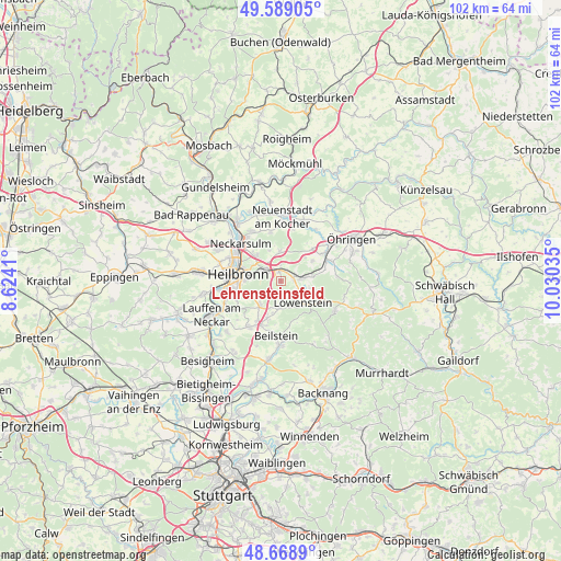
Lehrensteinsfeld GPS coordinates[2]
49° 7' 51.996" North, 9° 19' 37.992" East
| Map corner | latitude | longitude |
|---|---|---|
| Upper-left | 49.58905°, | 8.6241° |
| Center: | 49.13111°, | 9.32722° |
| Lower-right: | 48.6689°, | 10.03035° |
| Map W x H: | 102.3×102.3 km | = 63.6×63.6mi |
| max Lat: | 55.01917° ⇑81.4% North |
| Lehrensteinsfeld: | 49.13111° |
| min Lat: | ⇓18.6% South 47.40724° |
| min Long | Lehrensteinsfel | max Long |
| 5.92978° | 9.32722° | 14.98853° |
| W 39.6%⇐ | ⇒60.4% E |
Elevation
Elevation of Lehrensteinsfeld is 204 m = 669 ft, and this is 45.1 m = 148 ft below average elevation for this country.
| Max E: |
1256 m = 4121 ft | 53% |
| Avg. | 249.1 m = 817 ft | |
| Lehrensteinsfeld | 204 m = 669 ft | |
Min E: |
-5 m = -16 ft | 47% |
See also: Germany elevation on elevation.city.
Geographical zone
Lehrensteinsfeld is located in North temperate zone (between Tropic of Cancer and the Arctic Circle). Distance of this North polar circle is 1938.3 km =1204.4 mi to North.| Distance of | km | miles | from Lehrensteinsfeld |
|---|---|---|---|
| North Pole | 4544.2 | 2823.6 | to North |
| Arctic Circle | 1938.3 | 1204.4 | to North |
| Tropic Cancer | 2856.9 | 1775.2 | to South |
| Equator | 5462.9 | 3394.5 | to South |


Nearby cities:
15 places around Lehrensteinsfeld: (largest is in red/bold)
• Abstatt
7.5 km =4.7 mi,  200°
200°
• Beilstein
10 km =6.2 mi,  185°
185°
• Bretzfeld
9.7 km =6 mi,  56°
56°
• Eberstadt
5.5 km =3.4 mi,  355°
355°
• Ellhofen
1.8 km =1.1 mi,  347°
347°
• Erlenbach
6.3 km =3.9 mi,  317°
317°
• Flein
9 km =5.6 mi,  249°
249°
• Heilbronn
7.8 km =4.8 mi,  277°
277°
• Ilsfeld
10.3 km =6.4 mi,  215°
215°
• Löwenstein
5.5 km =3.4 mi,  135°
135°
• Neckarsulm
9.8 km =6.1 mi,  311°
311°
• Talheim
11.1 km =6.9 mi,  241°
241°
• Untergruppenbach
6 km =3.7 mi, 219°
• Weinsberg
3.6 km =2.2 mi, 307°
• Wüstenrot
11.2 km =7 mi,  119°
119°
Sources, notices
• [Note1] Compared only with cities in Germany existing in our database
• [Src1] Map data: © OpenStreetMap contributors (CC-BY-SA)
• [Src2] Other city data from geonames.org with taken over terms of usage.
• [Src3] Geographical zone / Annual Mean Temperature by Robert A. Rohde @ Wikipedia
