Oedheim geodata
Oedheim (Baden-Württemberg) is a seat of a fourth-order administrative division; located in Germany in Europe/Berlin (GMT+2) time zone. With population of 5,921 people, there are 2488 cities with bigger population in this country. Compared to other cities in Germany, 79.7% of cities are located further ↑North; 61.4% of cities are located further →East and 59.1% of cities have higher elevation than Oedheim. Note1
Administrative division(s):
- Level 1: Baden-Württemberg
- Level 2: Regierungsbezirk Stuttgart
- Level 3: Landkreis Heilbronn
- Level 4: Oedheim


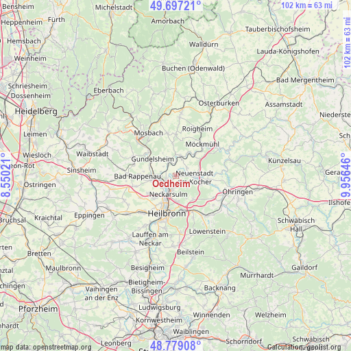
Oedheim GPS coordinates[2]
49° 14' 25.008" North, 9° 15' 11.988" East
| Map corner | latitude | longitude |
|---|---|---|
| Upper-left | 49.69721°, | 8.55021° |
| Center: | 49.24028°, | 9.25333° |
| Lower-right: | 48.77908°, | 9.95646° |
| Map W x H: | 102.1×102.1 km | = 63.4×63.4mi |
| max Lat: | 55.01917° ⇑79.7% North |
| Oedheim: | 49.24028° |
| min Lat: | ⇓20.3% South 47.40724° |
| min Long | Oedheim | max Long |
| 5.92978° | 9.25333° | 14.98853° |
| W 38.6%⇐ | ⇒61.4% E |
Elevation
Elevation of Oedheim is 160 m = 525 ft, and this is 89.1 m = 292 ft below average elevation for this country.
| Max E: |
1256 m = 4121 ft | 59.1% |
| Avg. | 249.1 m = 817 ft | |
| Oedheim | 160 m = 525 ft | |
Min E: |
-5 m = -16 ft | 40.9% |
See also: Germany elevation on elevation.city.
Geographical zone
Oedheim is located in North temperate zone (between Tropic of Cancer and the Arctic Circle). Distance of this North polar circle is 1926.2 km =1196.9 mi to North.| Distance of | km | miles | from Oedheim |
|---|---|---|---|
| North Pole | 4532.1 | 2816.1 | to North |
| Arctic Circle | 1926.2 | 1196.9 | to North |
| Tropic Cancer | 2869.1 | 1782.8 | to South |
| Equator | 5475 | 3402 | to South |


Nearby cities:
15 places around Oedheim: (largest is in red/bold)
• Bad Rappenau
11 km =6.8 mi,  268°
268°
• Bad Wimpfen
7.1 km =4.4 mi,  260°
260°
• Billigheim
12 km =7.5 mi,  0°
0°
• Eberstadt
8.3 km =5.2 mi,  143°
143°
• Ellhofen
11.5 km =7.1 mi,  154°
154°
• Erlenbach
7.6 km =4.7 mi,  171°
171°
• Gundelsheim
8.3 km =5.2 mi,  305°
305°
• Haßmersheim
10 km =6.2 mi, 311°
• Heilbronn
11.4 km =7.1 mi,  192°
192°
• Neckarsulm
6 km =3.7 mi,  199°
199°
• Neudenau
5.9 km =3.7 mi,  11°
11°
• Neuenstadt am Kocher
5.8 km =3.6 mi,  95°
95°
• Offenau
6.8 km =4.2 mi,  275°
275°
• Untereisesheim
4.9 km =3 mi,  229°
229°
• Weinsberg
10.2 km =6.3 mi, 165°
Sources, notices
• [Note1] Compared only with cities in Germany existing in our database
• [Src1] Map data: © OpenStreetMap contributors (CC-BY-SA)
• [Src2] Other city data from geonames.org with taken over terms of usage.
• [Src3] Geographical zone / Annual Mean Temperature by Robert A. Rohde @ Wikipedia
