Murnau am Staffelsee geodata
Murnau am Staffelsee (Bavaria) is a populated place; located in Germany in Europe/Berlin (GMT+2) time zone. With population of 11,958 people, there are 1373 cities with bigger population in this country. Compared to other cities in Germany, 99% of cities are located further ↑North; 70% of cities are located further ←West and 97.8% of cities have lower elevation than Murnau am Staffelsee. Note1
Administrative division(s):
- Level 1: Bavaria
- Level 2: Upper Bavaria
- Level 3: Landkreis Garmisch-Partenkirchen
- Level 4: Murnau a.Staffelsee, Markt


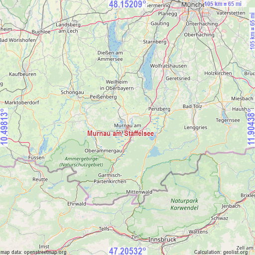
Murnau am Staffelsee GPS coordinates[2]
47° 40' 51.06" North, 11° 12' 4.5" East
| Map corner | latitude | longitude |
|---|---|---|
| Upper-left | 48.15209°, | 10.49813° |
| Center: | 47.68085°, | 11.20125° |
| Lower-right: | 47.20532°, | 11.90438° |
| Map W x H: | 105.3×105.3 km | = 65.4×65.4mi |
| max Lat: | 55.01917° ⇑99% North |
| Murnau am Staffelsee: | 47.68085° |
| min Lat: | ⇓1% South 47.40724° |
| min Long | Murnau am Staff | max Long |
| 5.92978° | 11.20125° | 14.98853° |
| W 70%⇐ | ⇒30% E |
Elevation
Elevation of Murnau am Staffelsee is 698 m = 2290 ft, and this is 448.9 m = 1473 ft above average elevation for this country.
| Max E: |
1256 m = 4121 ft | 2.2% |
| Murnau am Staffelsee | 698 m 2290 ft | |
| Avg. | 249.1 m = 817 ft | |
Min E: |
-5 m = -16 ft | 97.8% |
See also: Germany elevation on elevation.city.
Geographical zone
Murnau am Staffelsee is located in North temperate zone (between Tropic of Cancer and the Arctic Circle). Distance of this North polar circle is 2099.6 km =1304.6 mi to North.| Distance of | km | miles | from Murnau am Staffelsee |
|---|---|---|---|
| North Pole | 4705.4 | 2923.8 | to North |
| Arctic Circle | 2099.6 | 1304.6 | to North |
| Tropic Cancer | 2695.7 | 1675 | to South |
| Equator | 5301.6 | 3294.3 | to South |


Nearby cities:
15 places around Murnau am Staffelsee: (largest is in red/bold)
• Antdorf
11.2 km =7 mi,  45°
45°
• Eglfing
6 km =3.7 mi,  347°
347°
• Eschenlohe
9.1 km =5.7 mi,  188°
188°
• Großweil
7.5 km =4.7 mi,  94°
94°
• Habach
8.5 km =5.3 mi, 46°
• Huglfing
9.9 km =6.2 mi,  344°
344°
• Obersöchering
5.9 km =3.7 mi,  11°
11°
• Ohlstadt
5.8 km =3.6 mi,  155°
155°
• Riegsee
3.1 km =1.9 mi, 50°
• Schlehdorf
8.9 km =5.5 mi,  106°
106°
• Schwaigen
8.1 km =5 mi,  208°
208°
• Seehausen am Staffelsee
1.5 km =0.9 mi,  307°
307°
• Sindelsdorf
11 km =6.8 mi,  63°
63°
• Spatzenhausen
4 km =2.5 mi,  358°
358°
• Uffing
5.3 km =3.3 mi, 313°
Sources, notices
• [Note1] Compared only with cities in Germany existing in our database
• [Src1] Map data: © OpenStreetMap contributors (CC-BY-SA)
• [Src2] Other city data from geonames.org with taken over terms of usage.
• [Src3] Geographical zone / Annual Mean Temperature by Robert A. Rohde @ Wikipedia
