Steinhöfel geodata
Steinhöfel (Brandenburg) is a seat of a fourth-order administrative division; located in Germany in Europe/Berlin (GMT+2) time zone. With population of 4,672 people, there are 2950 cities with bigger population in this country. Compared to other cities in Germany, 76.2% of cities are located further ↓South; 98.6% of cities are located further ←West and 78.7% of cities have higher elevation than Steinhöfel. Note1


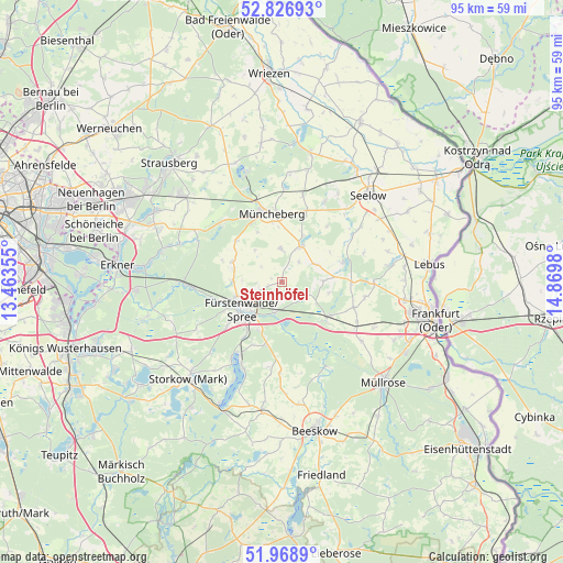
Steinhöfel GPS coordinates[2]
52° 24' 0" North, 14° 10' 0.012" East
| Map corner | latitude | longitude |
|---|---|---|
| Upper-left | 52.82693°, | 13.46355° |
| Center: | 52.4°, | 14.16667° |
| Lower-right: | 51.9689°, | 14.8698° |
| Map W x H: | 95.4×95.4 km | = 59.3×59.3mi |
| max Lat: | 55.01917° ⇑23.8% North |
| Steinhöfel: | 52.4° |
| min Lat: | ⇓76.2% South 47.40724° |
| min Long | Steinhöfel | max Long |
| 5.92978° | 14.16667° | 14.98853° |
| W 98.6%⇐ | ⇒1.4% E |
Elevation
Elevation of Steinhöfel is 51 m = 167 ft, and this is 198.1 m = 650 ft below average elevation for this country.
| Max E: |
1256 m = 4121 ft | 78.7% |
| Avg. | 249.1 m = 817 ft | |
| Steinhöfel | 51 m = 167 ft | |
Min E: |
-5 m = -16 ft | 21.3% |
See also: Germany elevation on elevation.city.
Geographical zone
Steinhöfel is located in North temperate zone (between Tropic of Cancer and the Arctic Circle). Distance of this North polar circle is 1574.8 km =978.5 mi to North.| Distance of | km | miles | from Steinhöfel |
|---|---|---|---|
| North Pole | 4180.7 | 2597.8 | to North |
| Arctic Circle | 1574.8 | 978.5 | to North |
| Tropic Cancer | 3220.4 | 2001.1 | to South |
| Equator | 5826.3 | 3620.3 | to South |


Nearby cities:
15 places around Steinhöfel: (largest is in red/bold)
• Bad Saarow
14.6 km =9.1 mi,  207°
207°
• Berkenbrück
5.7 km =3.5 mi,  191°
191°
• Briesen
9.8 km =6.1 mi,  129°
129°
• Diensdorf-Radlow
18.5 km =11.5 mi, 205°
• Falkenhagen
10.8 km =6.7 mi,  69°
69°
• Fürstenwalde
8.4 km =5.2 mi,  238°
238°
• Jacobsdorf
14.5 km =9 mi,  120°
120°
• Langewahl
8.7 km =5.4 mi, 211°
• Lietzen
14.1 km =8.8 mi,  56°
56°
• Müncheberg
12.1 km =7.5 mi,  350°
350°
• Rauen
12.1 km =7.5 mi,  231°
231°
• Reichenwalde
18.7 km =11.6 mi,  217°
217°
• Rietz Neuendorf
19.2 km =11.9 mi,  178°
178°
• Treplin
15.8 km =9.8 mi,  90°
90°
• Waldsieversdorf
17.1 km =10.6 mi,  337°
337°
Sources, notices
• [Note1] Compared only with cities in Germany existing in our database
• [Src1] Map data: © OpenStreetMap contributors (CC-BY-SA)
• [Src2] Other city data from geonames.org with taken over terms of usage.
• [Src3] Geographical zone / Annual Mean Temperature by Robert A. Rohde @ Wikipedia
