Mühlhausen geodata
Mühlhausen (Bavaria) is a seat of a fourth-order administrative division; located in Germany in Europe/Berlin (GMT+2) time zone. In our database, there are 11009 cities with bigger population. Compared to other cities in Germany, 80.8% of cities are located further ↑North; 73.4% of cities are located further ←West and 75.2% of cities have lower elevation than Mühlhausen. Note1
Administrative division(s):
- Level 1: Bavaria
- Level 2: Upper Palatinate
- Level 3: Landkreis Neumarkt in der Oberpfalz
- Level 4: Mühlhausen


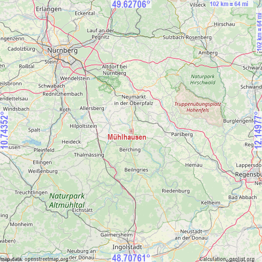
Mühlhausen GPS coordinates[2]
49° 10' 10.092" North, 11° 26' 47.904" East
| Map corner | latitude | longitude |
|---|---|---|
| Upper-left | 49.62706°, | 10.74352° |
| Center: | 49.16947°, | 11.44664° |
| Lower-right: | 48.70761°, | 12.14977° |
| Map W x H: | 102.2×102.2 km | = 63.5×63.5mi |
| max Lat: | 55.01917° ⇑80.8% North |
| Mühlhausen: | 49.16947° |
| min Lat: | ⇓19.2% South 47.40724° |
| min Long | Mühlhausen | max Long |
| 5.92978° | 11.44664° | 14.98853° |
| W 73.4%⇐ | ⇒26.6% E |
Elevation
Elevation of Mühlhausen is 399 m = 1309 ft, and this is 149.9 m = 492 ft above average elevation for this country.
| Max E: |
1256 m = 4121 ft | 24.8% |
| Mühlhausen | 399 m 1309 ft | |
| Avg. | 249.1 m = 817 ft | |
Min E: |
-5 m = -16 ft | 75.2% |
See also: Germany elevation on elevation.city.
Geographical zone
Mühlhausen is located in North temperate zone (between Tropic of Cancer and the Arctic Circle). Distance of this North polar circle is 1934 km =1201.7 mi to North.| Distance of | km | miles | from Mühlhausen |
|---|---|---|---|
| North Pole | 4539.9 | 2821 | to North |
| Arctic Circle | 1934 | 1201.7 | to North |
| Tropic Cancer | 2861.2 | 1777.9 | to South |
| Equator | 5467.1 | 3397.1 | to South |


Nearby cities:
15 places around Mühlhausen: (largest is in red/bold)
• Allersberg
17.8 km =11.1 mi,  300°
300°
• Berching
7 km =4.3 mi,  183°
183°
• Berg bei Neumarkt in der Oberpfalz
18.1 km =11.2 mi,  358°
358°
• Berngau
9.6 km =6 mi,  339°
339°
• Deining
9.2 km =5.7 mi,  47°
47°
• Dietfurt
18 km =11.2 mi,  145°
145°
• Freystadt
9.1 km =5.7 mi,  291°
291°
• Greding
15.1 km =9.4 mi,  205°
205°
• Neumarkt in der Oberpfalz
12.4 km =7.7 mi,  5°
5°
• Pilsach
17.4 km =10.8 mi, 13°
• Postbauer-Heng
16.4 km =10.2 mi, 336°
• Pyrbaum
18.3 km =11.4 mi,  320°
320°
• Sengenthal
7.2 km =4.5 mi, 11°
• Seubersdorf
13.1 km =8.1 mi,  93°
93°
• Velburg
17.8 km =11.1 mi,  66°
66°
Sources, notices
• [Note1] Compared only with cities in Germany existing in our database
• [Src1] Map data: © OpenStreetMap contributors (CC-BY-SA)
• [Src2] Other city data from geonames.org with taken over terms of usage.
• [Src3] Geographical zone / Annual Mean Temperature by Robert A. Rohde @ Wikipedia
