Freystadt geodata
Freystadt (Bavaria) is a populated place; located in Germany in Europe/Berlin (GMT+2) time zone. With population of 8,555 people, there are 1866 cities with bigger population in this country. Compared to other cities in Germany, 80.3% of cities are located further ↑North; 71.7% of cities are located further ←West and 76.2% of cities have lower elevation than Freystadt. Note1
Administrative division(s):
- Level 1: Bavaria
- Level 2: Upper Palatinate
- Level 3: Landkreis Neumarkt in der Oberpfalz
- Level 4: Freystadt


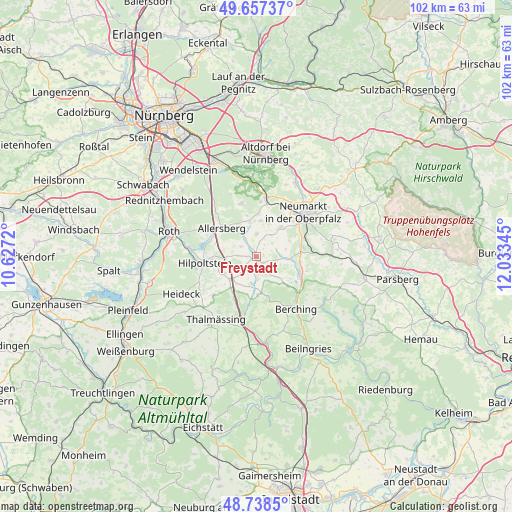
Freystadt GPS coordinates[2]
49° 12' 0.252" North, 11° 19' 49.152" East
| Map corner | latitude | longitude |
|---|---|---|
| Upper-left | 49.65737°, | 10.6272° |
| Center: | 49.20007°, | 11.33032° |
| Lower-right: | 48.7385°, | 12.03345° |
| Map W x H: | 102.2×102.2 km | = 63.5×63.5mi |
| max Lat: | 55.01917° ⇑80.3% North |
| Freystadt: | 49.20007° |
| min Lat: | ⇓19.7% South 47.40724° |
| min Long | Freystadt | max Long |
| 5.92978° | 11.33032° | 14.98853° |
| W 71.7%⇐ | ⇒28.3% E |
Elevation
Elevation of Freystadt is 407 m = 1335 ft, and this is 157.9 m = 518 ft above average elevation for this country.
| Max E: |
1256 m = 4121 ft | 23.8% |
| Freystadt | 407 m 1335 ft | |
| Avg. | 249.1 m = 817 ft | |
Min E: |
-5 m = -16 ft | 76.2% |
See also: Germany elevation on elevation.city.
Geographical zone
Freystadt is located in North temperate zone (between Tropic of Cancer and the Arctic Circle). Distance of this North polar circle is 1930.6 km =1199.6 mi to North.| Distance of | km | miles | from Freystadt |
|---|---|---|---|
| North Pole | 4536.5 | 2818.8 | to North |
| Arctic Circle | 1930.6 | 1199.6 | to North |
| Tropic Cancer | 2864.6 | 1780 | to South |
| Equator | 5470.5 | 3399.2 | to South |


Nearby cities:
15 places around Freystadt: (largest is in red/bold)
• Allersberg
8.9 km =5.5 mi,  309°
309°
• Berching
13.1 km =8.1 mi,  142°
142°
• Berg bei Neumarkt in der Oberpfalz
16.6 km =10.3 mi,  28°
28°
• Berngau
7.5 km =4.7 mi,  42°
42°
• Burgthann
17 km =10.6 mi,  355°
355°
• Deining
15.5 km =9.6 mi,  79°
79°
• Greding
17.1 km =10.6 mi,  173°
173°
• Heideck
16.5 km =10.3 mi,  243°
243°
• Hilpoltstein
10.2 km =6.3 mi,  263°
263°
• Mühlhausen
9.1 km =5.7 mi,  111°
111°
• Neumarkt in der Oberpfalz
13.1 km =8.1 mi,  47°
47°
• Postbauer-Heng
11.9 km =7.4 mi,  9°
9°
• Pyrbaum
11.2 km =7 mi,  343°
343°
• Sengenthal
10.6 km =6.6 mi,  69°
69°
• Thalmässing
14.7 km =9.1 mi,  212°
212°
Sources, notices
• [Note1] Compared only with cities in Germany existing in our database
• [Src1] Map data: © OpenStreetMap contributors (CC-BY-SA)
• [Src2] Other city data from geonames.org with taken over terms of usage.
• [Src3] Geographical zone / Annual Mean Temperature by Robert A. Rohde @ Wikipedia
