Allersberg geodata
Allersberg (Bavaria) is a populated place; located in Germany in Europe/Berlin (GMT+2) time zone. With population of 8,054 people, there are 1948 cities with bigger population in this country. Compared to other cities in Germany, 79.5% of cities are located further ↑North; 70.5% of cities are located further ←West and 73.6% of cities have lower elevation than Allersberg. Note1
Administrative division(s):
- Level 1: Bavaria
- Level 2: Regierungsbezirk Mittelfranken
- Level 3: Landkreis Roth
- Level 4: Allersberg, Markt


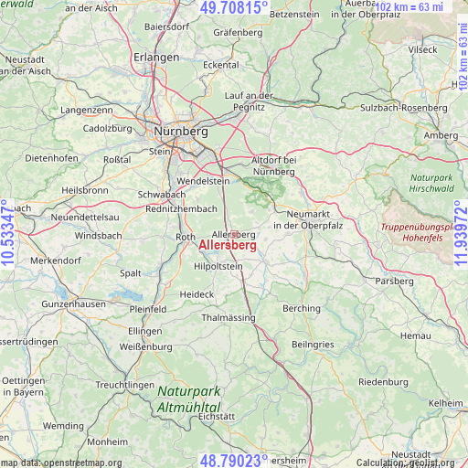
Allersberg GPS coordinates[2]
49° 15' 4.752" North, 11° 14' 11.724" East
| Map corner | latitude | longitude |
|---|---|---|
| Upper-left | 49.70815°, | 10.53347° |
| Center: | 49.25132°, | 11.23659° |
| Lower-right: | 48.79023°, | 11.93972° |
| Map W x H: | 102.1×102.1 km | = 63.4×63.4mi |
| max Lat: | 55.01917° ⇑79.5% North |
| Allersberg: | 49.25132° |
| min Lat: | ⇓20.5% South 47.40724° |
| min Long | Allersberg | max Long |
| 5.92978° | 11.23659° | 14.98853° |
| W 70.5%⇐ | ⇒29.5% E |
Elevation
Elevation of Allersberg is 387 m = 1270 ft, and this is 137.9 m = 452 ft above average elevation for this country.
| Max E: |
1256 m = 4121 ft | 26.4% |
| Allersberg | 387 m 1270 ft | |
| Avg. | 249.1 m = 817 ft | |
Min E: |
-5 m = -16 ft | 73.6% |
See also: Germany elevation on elevation.city.
Geographical zone
Allersberg is located in North temperate zone (between Tropic of Cancer and the Arctic Circle). Distance of this North polar circle is 1924.9 km =1196.1 mi to North.| Distance of | km | miles | from Allersberg |
|---|---|---|---|
| North Pole | 4530.8 | 2815.3 | to North |
| Arctic Circle | 1924.9 | 1196.1 | to North |
| Tropic Cancer | 2870.3 | 1783.5 | to South |
| Equator | 5476.2 | 3402.8 | to South |


Nearby cities:
15 places around Allersberg: (largest is in red/bold)
• Berngau
11.9 km =7.4 mi,  90°
90°
• Burgthann
12.4 km =7.7 mi,  25°
25°
• Büchenbach
13 km =8.1 mi,  278°
278°
• Feucht
14 km =8.7 mi,  353°
353°
• Freystadt
8.9 km =5.5 mi,  129°
129°
• Heideck
15.3 km =9.5 mi,  211°
211°
• Hilpoltstein
7.5 km =4.7 mi, 206°
• Neumarkt in der Oberpfalz
16.7 km =10.4 mi,  78°
78°
• Postbauer-Heng
10.6 km =6.6 mi,  55°
55°
• Pyrbaum
6.2 km =3.9 mi,  35°
35°
• Rednitzhembach
12.6 km =7.8 mi,  295°
295°
• Roth
10.6 km =6.6 mi,  267°
267°
• Schwarzenbruck
11.8 km =7.3 mi,  2°
2°
• Wendelstein
12.8 km =8 mi,  330°
330°
• Winkelhaid
16 km =9.9 mi,  16°
16°
Sources, notices
• [Note1] Compared only with cities in Germany existing in our database
• [Src1] Map data: © OpenStreetMap contributors (CC-BY-SA)
• [Src2] Other city data from geonames.org with taken over terms of usage.
• [Src3] Geographical zone / Annual Mean Temperature by Robert A. Rohde @ Wikipedia
