Greding geodata
Greding (Bavaria) is a populated place; located in Germany in Europe/Berlin (GMT+2) time zone. With population of 7,238 people, there are 2131 cities with bigger population in this country. Compared to other cities in Germany, 82.4% of cities are located further ↑North; 72.1% of cities are located further ←West and 74.4% of cities have lower elevation than Greding. Note1
Administrative division(s):
- Level 1: Bavaria
- Level 2: Regierungsbezirk Mittelfranken
- Level 3: Landkreis Roth
- Level 4: Greding


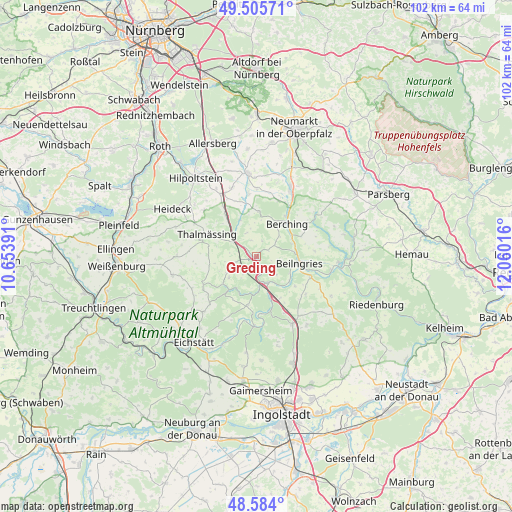
Greding GPS coordinates[2]
49° 2' 49.164" North, 11° 21' 25.308" East
| Map corner | latitude | longitude |
|---|---|---|
| Upper-left | 49.50571°, | 10.65391° |
| Center: | 49.04699°, | 11.35703° |
| Lower-right: | 48.584°, | 12.06016° |
| Map W x H: | 102.5×102.5 km | = 63.7×63.7mi |
| max Lat: | 55.01917° ⇑82.4% North |
| Greding: | 49.04699° |
| min Lat: | ⇓17.6% South 47.40724° |
| min Long | Greding | max Long |
| 5.92978° | 11.35703° | 14.98853° |
| W 72.1%⇐ | ⇒27.9% E |
Elevation
Elevation of Greding is 393 m = 1289 ft, and this is 143.9 m = 472 ft above average elevation for this country.
| Max E: |
1256 m = 4121 ft | 25.6% |
| Greding | 393 m 1289 ft | |
| Avg. | 249.1 m = 817 ft | |
Min E: |
-5 m = -16 ft | 74.4% |
See also: Germany elevation on elevation.city.
Geographical zone
Greding is located in North temperate zone (between Tropic of Cancer and the Arctic Circle). Distance of this North polar circle is 1947.7 km =1210.2 mi to North.| Distance of | km | miles | from Greding |
|---|---|---|---|
| North Pole | 4553.5 | 2829.4 | to North |
| Arctic Circle | 1947.7 | 1210.2 | to North |
| Tropic Cancer | 2847.6 | 1769.4 | to South |
| Equator | 5453.5 | 3388.6 | to South |


Nearby cities:
15 places around Greding: (largest is in red/bold)
• Berching
9.1 km =5.7 mi,  42°
42°
• Bergen
17.9 km =11.1 mi,  279°
279°
• Burgsalach
19 km =11.8 mi,  265°
265°
• Böhmfeld
20.7 km =12.9 mi,  177°
177°
• Denkendorf
15.1 km =9.4 mi,  151°
151°
• Dietfurt
16.8 km =10.4 mi,  94°
94°
• Freystadt
17.1 km =10.6 mi,  353°
353°
• Heideck
19.3 km =12 mi,  299°
299°
• Hilpoltstein
20 km =12.4 mi,  322°
322°
• Mühlhausen
15.1 km =9.4 mi,  25°
25°
• Nennslingen
16.5 km =10.3 mi, 270°
• Pollenfeld
15.7 km =9.8 mi,  226°
226°
• Raitenbuch
17.3 km =10.7 mi,  258°
258°
• Thalmässing
10.9 km =6.8 mi,  294°
294°
• Walting
15.1 km =9.4 mi,  196°
196°
Sources, notices
• [Note1] Compared only with cities in Germany existing in our database
• [Src1] Map data: © OpenStreetMap contributors (CC-BY-SA)
• [Src2] Other city data from geonames.org with taken over terms of usage.
• [Src3] Geographical zone / Annual Mean Temperature by Robert A. Rohde @ Wikipedia
