Pyrbaum geodata
Pyrbaum (Bavaria) is a populated place; located in Germany in Europe/Berlin (GMT+2) time zone. With population of 5,836 people, there are 2517 cities with bigger population in this country. Compared to other cities in Germany, 78.8% of cities are located further ↑North; 71.1% of cities are located further ←West and 80.9% of cities have lower elevation than Pyrbaum. Note1
Administrative division(s):
- Level 1: Bavaria
- Level 2: Upper Palatinate
- Level 3: Landkreis Neumarkt in der Oberpfalz
- Level 4: Pyrbaum, Markt


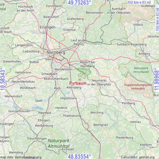
Pyrbaum GPS coordinates[2]
49° 17' 46.392" North, 11° 17' 11.58" East
| Map corner | latitude | longitude |
|---|---|---|
| Upper-left | 49.75263°, | 10.58343° |
| Center: | 49.29622°, | 11.28655° |
| Lower-right: | 48.83554°, | 11.98968° |
| Map W x H: | 102×102 km | = 63.4×63.4mi |
| max Lat: | 55.01917° ⇑78.8% North |
| Pyrbaum: | 49.29622° |
| min Lat: | ⇓21.2% South 47.40724° |
| min Long | Pyrbaum | max Long |
| 5.92978° | 11.28655° | 14.98853° |
| W 71.1%⇐ | ⇒28.9% E |
Elevation
Elevation of Pyrbaum is 439 m = 1440 ft, and this is 189.9 m = 623 ft above average elevation for this country.
| Max E: |
1256 m = 4121 ft | 19.1% |
| Pyrbaum | 439 m 1440 ft | |
| Avg. | 249.1 m = 817 ft | |
Min E: |
-5 m = -16 ft | 80.9% |
See also: Germany elevation on elevation.city.
Geographical zone
Pyrbaum is located in North temperate zone (between Tropic of Cancer and the Arctic Circle). Distance of this North polar circle is 1919.9 km =1193 mi to North.| Distance of | km | miles | from Pyrbaum |
|---|---|---|---|
| North Pole | 4525.8 | 2812.2 | to North |
| Arctic Circle | 1919.9 | 1193 | to North |
| Tropic Cancer | 2875.3 | 1786.6 | to South |
| Equator | 5481.2 | 3405.9 | to South |


Nearby cities:
15 places around Pyrbaum: (largest is in red/bold)
• Allersberg
6.2 km =3.9 mi,  215°
215°
• Altdorf
11.2 km =7 mi,  27°
27°
• Berg bei Neumarkt in der Oberpfalz
11.7 km =7.3 mi,  70°
70°
• Berngau
9.7 km =6 mi,  121°
121°
• Burgthann
6.5 km =4 mi,  16°
16°
• Feucht
10.3 km =6.4 mi,  329°
329°
• Freystadt
11.2 km =7 mi,  163°
163°
• Hilpoltstein
13.7 km =8.5 mi,  210°
210°
• Neumarkt in der Oberpfalz
12.9 km =8 mi,  97°
97°
• Postbauer-Heng
5.2 km =3.2 mi,  78°
78°
• Schwarzenbruck
7.5 km =4.7 mi,  335°
335°
• Sengenthal
14.8 km =9.2 mi, 118°
• Stöckelsberg
14.7 km =9.1 mi,  48°
48°
• Wendelstein
11.7 km =7.3 mi,  302°
302°
• Winkelhaid
10.4 km =6.5 mi,  4°
4°
Sources, notices
• [Note1] Compared only with cities in Germany existing in our database
• [Src1] Map data: © OpenStreetMap contributors (CC-BY-SA)
• [Src2] Other city data from geonames.org with taken over terms of usage.
• [Src3] Geographical zone / Annual Mean Temperature by Robert A. Rohde @ Wikipedia
