Müden geodata
Müden (Rheinland-Pfalz) is a populated place; located in Germany in Europe/Berlin (GMT+2) time zone. With population of 689 people, there are 8366 cities with bigger population in this country. Compared to other cities in Germany, 59.2% of cities are located further ↑North; 89.4% of cities are located further →East and 70.9% of cities have higher elevation than Müden. Note1
Administrative division(s):
- Level 1: Rheinland-Pfalz
- Level 3: Landkreis Cochem-Zell
- Level 4: Müden (Mosel)


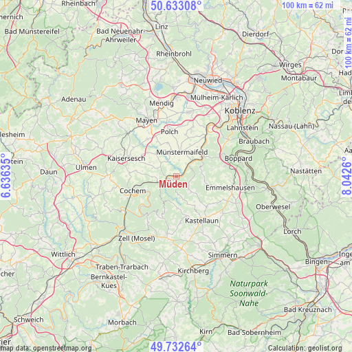
Müden GPS coordinates[2]
50° 11' 5.928" North, 7° 20' 22.092" East
| Map corner | latitude | longitude |
|---|---|---|
| Upper-left | 50.63308°, | 6.63635° |
| Center: | 50.18498°, | 7.33947° |
| Lower-right: | 49.73264°, | 8.0426° |
| Map W x H: | 100.1×100.1 km | = 62.2×62.2mi |
| max Lat: | 55.01917° ⇑59.2% North |
| Müden: | 50.18498° |
| min Lat: | ⇓40.8% South 47.40724° |
| min Long | Müden | max Long |
| 5.92978° | 7.33947° | 14.98853° |
| W 10.6%⇐ | ⇒89.4% E |
Elevation
Elevation of Müden is 86 m = 282 ft, and this is 163.1 m = 535 ft below average elevation for this country.
| Max E: |
1256 m = 4121 ft | 70.9% |
| Avg. | 249.1 m = 817 ft | |
| Müden | 86 m = 282 ft | |
Min E: |
-5 m = -16 ft | 29.1% |
See also: Germany elevation on elevation.city.
Geographical zone
Müden is located in North temperate zone (between Tropic of Cancer and the Arctic Circle). Distance of this North polar circle is 1821.1 km =1131.6 mi to North.| Distance of | km | miles | from Müden |
|---|---|---|---|
| North Pole | 4427 | 2750.8 | to North |
| Arctic Circle | 1821.1 | 1131.6 | to North |
| Tropic Cancer | 2974.1 | 1848 | to South |
| Equator | 5580 | 3467.3 | to South |


Nearby cities:
15 places around Müden: (largest is in red/bold)
• Brieden
5.2 km =3.2 mi,  267°
267°
• Brohl
5.7 km =3.5 mi,  311°
311°
• Burgen
4.6 km =2.9 mi,  50°
50°
• Dommershausen
5.8 km =3.6 mi,  132°
132°
• Lahr
6.9 km =4.3 mi,  164°
164°
• Lieg
5.8 km =3.6 mi,  172°
172°
• Lütz
2.2 km =1.4 mi, 159°
• Macken
4.3 km =2.7 mi,  92°
92°
• Morshausen
6.9 km =4.3 mi,  75°
75°
• Moselkern
2.5 km =1.6 mi,  64°
64°
• Möntenich
5 km =3.1 mi,  324°
324°
• Pillig
6.3 km =3.9 mi,  341°
341°
• Pommern
4.5 km =2.8 mi,  243°
243°
• Treis-Karden
3 km =1.9 mi, 240°
• Wierschem
4.6 km =2.9 mi,  10°
10°
Sources, notices
• [Note1] Compared only with cities in Germany existing in our database
• [Src1] Map data: © OpenStreetMap contributors (CC-BY-SA)
• [Src2] Other city data from geonames.org with taken over terms of usage.
• [Src3] Geographical zone / Annual Mean Temperature by Robert A. Rohde @ Wikipedia
