Burgen geodata
Burgen (Rheinland-Pfalz) is a seat of a fourth-order administrative division; located in Germany in Europe/Berlin (GMT+2) time zone. With population of 828 people, there are 7783 cities with bigger population in this country. Compared to other cities in Germany, 58.8% of cities are located further ↑North; 88.7% of cities are located further →East and 71.5% of cities have higher elevation than Burgen. Note1
Administrative division(s):
- Level 1: Rheinland-Pfalz
- Level 3: Landkreis Mayen-Koblenz
- Level 4: Burgen


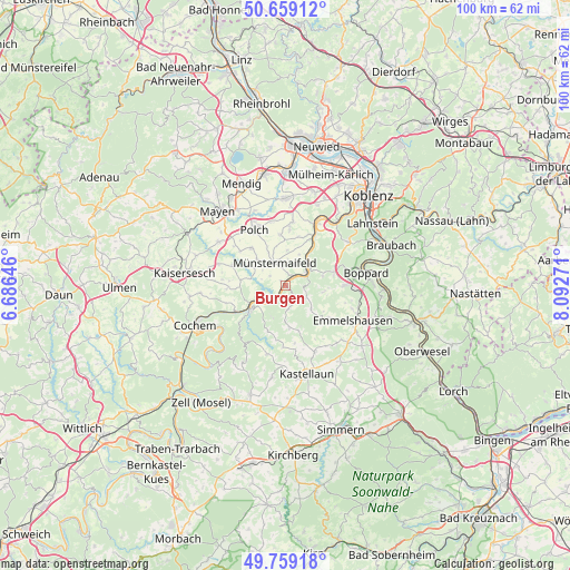
Burgen GPS coordinates[2]
50° 12' 40.572" North, 7° 23' 22.524" East
| Map corner | latitude | longitude |
|---|---|---|
| Upper-left | 50.65912°, | 6.68646° |
| Center: | 50.21127°, | 7.38959° |
| Lower-right: | 49.75918°, | 8.09271° |
| Map W x H: | 100.1×100.1 km | = 62.2×62.2mi |
| max Lat: | 55.01917° ⇑58.8% North |
| Burgen: | 50.21127° |
| min Lat: | ⇓41.2% South 47.40724° |
| min Long | Burgen | max Long |
| 5.92978° | 7.38959° | 14.98853° |
| W 11.3%⇐ | ⇒88.7% E |
Elevation
Elevation of Burgen is 81 m = 266 ft, and this is 168.1 m = 552 ft below average elevation for this country.
| Max E: |
1256 m = 4121 ft | 71.5% |
| Avg. | 249.1 m = 817 ft | |
| Burgen | 81 m = 266 ft | |
Min E: |
-5 m = -16 ft | 28.5% |
See also: Germany elevation on elevation.city.
Geographical zone
Burgen is located in North temperate zone (between Tropic of Cancer and the Arctic Circle). Distance of this North polar circle is 1818.2 km =1129.8 mi to North.| Distance of | km | miles | from Burgen |
|---|---|---|---|
| North Pole | 4424.1 | 2749 | to North |
| Arctic Circle | 1818.2 | 1129.8 | to North |
| Tropic Cancer | 2977.1 | 1849.9 | to South |
| Equator | 5583 | 3469.1 | to South |


Nearby cities:
15 places around Burgen: (largest is in red/bold)
• Alken
6.1 km =3.8 mi,  44°
44°
• Beulich
5.3 km =3.3 mi,  125°
125°
• Brodenbach
4.9 km =3 mi,  60°
60°
• Hatzenport
3.1 km =1.9 mi, 38°
• Kalt
6.2 km =3.9 mi,  3°
3°
• Löf
4 km =2.5 mi,  51°
51°
• Lütz
5.7 km =3.5 mi,  209°
209°
• Macken
3.2 km =2 mi,  166°
166°
• Morshausen
3.4 km =2.1 mi,  111°
111°
• Moselkern
2.3 km =1.4 mi,  215°
215°
• Möntenich
6.5 km =4 mi,  279°
279°
• Müden
4.6 km =2.9 mi,  230°
230°
• Münstermaifeld
4.4 km =2.7 mi,  333°
333°
• Pillig
6.4 km =4 mi,  299°
299°
• Wierschem
3.1 km =1.9 mi, 300°
Sources, notices
• [Note1] Compared only with cities in Germany existing in our database
• [Src1] Map data: © OpenStreetMap contributors (CC-BY-SA)
• [Src2] Other city data from geonames.org with taken over terms of usage.
• [Src3] Geographical zone / Annual Mean Temperature by Robert A. Rohde @ Wikipedia
