Moselkern geodata
Moselkern (Rheinland-Pfalz) is a seat of a fourth-order administrative division; located in Germany in Europe/Berlin (GMT+2) time zone. With population of 705 people, there are 8290 cities with bigger population in this country. Compared to other cities in Germany, 59.1% of cities are located further ↑North; 88.9% of cities are located further →East and 70.7% of cities have higher elevation than Moselkern. Note1
Administrative division(s):
- Level 1: Rheinland-Pfalz
- Level 3: Landkreis Cochem-Zell
- Level 4: Moselkern


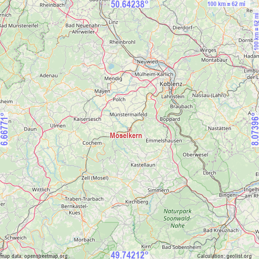
Moselkern GPS coordinates[2]
50° 11' 39.732" North, 7° 22' 15.024" East
| Map corner | latitude | longitude |
|---|---|---|
| Upper-left | 50.64238°, | 6.66771° |
| Center: | 50.19437°, | 7.37084° |
| Lower-right: | 49.74212°, | 8.07396° |
| Map W x H: | 100.1×100.1 km | = 62.2×62.2mi |
| max Lat: | 55.01917° ⇑59.1% North |
| Moselkern: | 50.19437° |
| min Lat: | ⇓40.9% South 47.40724° |
| min Long | Moselkern | max Long |
| 5.92978° | 7.37084° | 14.98853° |
| W 11.1%⇐ | ⇒88.9% E |
Elevation
Elevation of Moselkern is 87 m = 285 ft, and this is 162.1 m = 532 ft below average elevation for this country.
| Max E: |
1256 m = 4121 ft | 70.7% |
| Avg. | 249.1 m = 817 ft | |
| Moselkern | 87 m = 285 ft | |
Min E: |
-5 m = -16 ft | 29.3% |
See also: Germany elevation on elevation.city.
Geographical zone
Moselkern is located in North temperate zone (between Tropic of Cancer and the Arctic Circle). Distance of this North polar circle is 1820.1 km =1131 mi to North.| Distance of | km | miles | from Moselkern |
|---|---|---|---|
| North Pole | 4426 | 2750.2 | to North |
| Arctic Circle | 1820.1 | 1131 | to North |
| Tropic Cancer | 2975.2 | 1848.7 | to South |
| Equator | 5581.1 | 3467.9 | to South |


Nearby cities:
15 places around Moselkern: (largest is in red/bold)
• Beulich
5.8 km =3.6 mi,  102°
102°
• Burgen
2.3 km =1.4 mi,  35°
35°
• Dommershausen
5.4 km =3.4 mi,  157°
157°
• Hatzenport
5.4 km =3.4 mi, 36°
• Lieg
6.9 km =4.3 mi,  192°
192°
• Löf
6.2 km =3.9 mi,  45°
45°
• Lütz
3.4 km =2.1 mi,  205°
205°
• Macken
2.4 km =1.5 mi,  120°
120°
• Morshausen
4.5 km =2.8 mi,  81°
81°
• Möntenich
5.9 km =3.7 mi,  300°
300°
• Müden
2.5 km =1.6 mi,  244°
244°
• Münstermaifeld
5.8 km =3.6 mi,  353°
353°
• Pillig
6.5 km =4 mi,  319°
319°
• Treis-Karden
5.5 km =3.4 mi, 242°
• Wierschem
3.7 km =2.3 mi,  338°
338°
Sources, notices
• [Note1] Compared only with cities in Germany existing in our database
• [Src1] Map data: © OpenStreetMap contributors (CC-BY-SA)
• [Src2] Other city data from geonames.org with taken over terms of usage.
• [Src3] Geographical zone / Annual Mean Temperature by Robert A. Rohde @ Wikipedia
