Moorweg geodata
Moorweg (Lower Saxony) is a seat of a fourth-order administrative division; located in Germany in Europe/Berlin (GMT+2) time zone. With population of 928 people, there are 7425 cities with bigger population in this country. Compared to other cities in Germany, 87.5% of cities are located further ↓South; 85.4% of cities are located further →East and 97.6% of cities have higher elevation than Moorweg. Note1


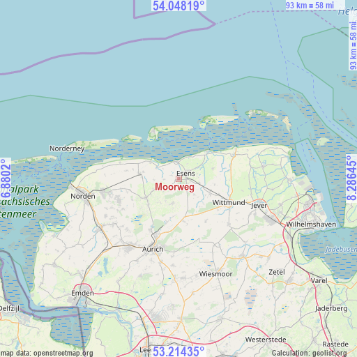
Moorweg GPS coordinates[2]
53° 37' 59.988" North, 7° 34' 59.988" East
| Map corner | latitude | longitude |
|---|---|---|
| Upper-left | 54.04819°, | 6.8802° |
| Center: | 53.63333°, | 7.58333° |
| Lower-right: | 53.21435°, | 8.28645° |
| Map W x H: | 92.7×92.7 km | = 57.6×57.6mi |
| max Lat: | 55.01917° ⇑12.5% North |
| Moorweg: | 53.63333° |
| min Lat: | ⇓87.5% South 47.40724° |
| min Long | Moorweg | max Long |
| 5.92978° | 7.58333° | 14.98853° |
| W 14.6%⇐ | ⇒85.4% E |
Elevation
Elevation of Moorweg is 3 m = 10 ft, and this is 246.1 m = 807 ft below average elevation for this country.
| Max E: |
1256 m = 4121 ft | 97.6% |
| Avg. | 249.1 m = 817 ft | |
| Moorweg | 3 m = 10 ft | |
Min E: |
-5 m = -16 ft | 2.4% |
See also: Germany elevation on elevation.city.
Geographical zone
Moorweg is located in North temperate zone (between Tropic of Cancer and the Arctic Circle). Distance of this North polar circle is 1437.7 km =893.3 mi to North.| Distance of | km | miles | from Moorweg |
|---|---|---|---|
| North Pole | 4043.6 | 2512.6 | to North |
| Arctic Circle | 1437.7 | 893.3 | to North |
| Tropic Cancer | 3357.5 | 2086.3 | to South |
| Equator | 5963.5 | 3705.5 | to South |


Nearby cities:
15 places around Moorweg: (largest is in red/bold)
• Bensersiel
4.4 km =2.7 mi,  355°
355°
• Blomberg
6.5 km =4 mi,  194°
194°
• Dornum
10.2 km =6.3 mi,  278°
278°
• Dunum
5.8 km =3.6 mi,  130°
130°
• Esens
2.6 km =1.6 mi,  48°
48°
• Eversmeer
12.8 km =8 mi,  230°
230°
• Holtgast
0.7 km =0.4 mi, 234°
• Nenndorf
11.4 km =7.1 mi,  240°
240°
• Neuharlingersiel
10.8 km =6.7 mi, 46°
• Ostochtersum
4.8 km =3 mi, 231°
• Schweindorf
8.5 km =5.3 mi, 244°
• Stedesdorf
5.5 km =3.4 mi,  90°
90°
• Utarp
6.8 km =4.2 mi,  254°
254°
• Werdum
9.3 km =5.8 mi,  73°
73°
• Westerholt
9.5 km =5.9 mi, 247°
Sources, notices
• [Note1] Compared only with cities in Germany existing in our database
• [Src1] Map data: © OpenStreetMap contributors (CC-BY-SA)
• [Src2] Other city data from geonames.org with taken over terms of usage.
• [Src3] Geographical zone / Annual Mean Temperature by Robert A. Rohde @ Wikipedia
