Bensersiel geodata
Bensersiel (Lower Saxony) is a populated place; located in Germany in Europe/Berlin (GMT+2) time zone. With population of 1,000 people, there are 7180 cities with bigger population in this country. Compared to other cities in Germany, 88.2% of cities are located further ↓South; 85.5% of cities are located further →East and 98.6% of cities have higher elevation than Bensersiel. Note1


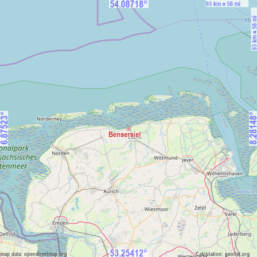
Bensersiel GPS coordinates[2]
53° 40' 21.756" North, 7° 34' 42.06" East
| Map corner | latitude | longitude |
|---|---|---|
| Upper-left | 54.08718°, | 6.87523° |
| Center: | 53.67271°, | 7.57835° |
| Lower-right: | 53.25412°, | 8.28148° |
| Map W x H: | 92.6×92.6 km | = 57.5×57.5mi |
| max Lat: | 55.01917° ⇑11.8% North |
| Bensersiel: | 53.67271° |
| min Lat: | ⇓88.2% South 47.40724° |
| min Long | Bensersiel | max Long |
| 5.92978° | 7.57835° | 14.98853° |
| W 14.5%⇐ | ⇒85.5% E |
Elevation
Elevation of Bensersiel is 1 m = 3 ft, and this is 248.1 m = 814 ft below average elevation for this country.
| Max E: |
1256 m = 4121 ft | 98.6% |
| Avg. | 249.1 m = 817 ft | |
| Bensersiel | 1 m = 3 ft | |
Min E: |
-5 m = -16 ft | 1.4% |
See also: Germany elevation on elevation.city.
Geographical zone
Bensersiel is located in North temperate zone (between Tropic of Cancer and the Arctic Circle). Distance of this North polar circle is 1433.3 km =890.6 mi to North.| Distance of | km | miles | from Bensersiel |
|---|---|---|---|
| North Pole | 4039.2 | 2509.8 | to North |
| Arctic Circle | 1433.3 | 890.6 | to North |
| Tropic Cancer | 3361.9 | 2089 | to South |
| Equator | 5967.8 | 3708.2 | to South |


Nearby cities:
15 places around Bensersiel: (largest is in red/bold)
• Blomberg
10.7 km =6.6 mi,  187°
187°
• Dornum
10.2 km =6.3 mi,  253°
253°
• Dunum
9.4 km =5.8 mi,  149°
149°
• Esens
3.5 km =2.2 mi,  139°
139°
• Holtgast
4.8 km =3 mi,  182°
182°
• Langeoog
10.6 km =6.6 mi,  323°
323°
• Moorweg
4.4 km =2.7 mi, 175°
• Neuharlingersiel
8.7 km =5.4 mi,  69°
69°
• Ostochtersum
8.2 km =5.1 mi,  204°
204°
• Schweindorf
10.9 km =6.8 mi,  222°
222°
• Spiekeroog
13.3 km =8.3 mi,  35°
35°
• Stedesdorf
7.3 km =4.5 mi,  126°
126°
• Utarp
8.8 km =5.5 mi,  225°
225°
• Werdum
9.4 km =5.8 mi,  100°
100°
• Westerholt
11.7 km =7.3 mi, 226°
Sources, notices
• [Note1] Compared only with cities in Germany existing in our database
• [Src1] Map data: © OpenStreetMap contributors (CC-BY-SA)
• [Src2] Other city data from geonames.org with taken over terms of usage.
• [Src3] Geographical zone / Annual Mean Temperature by Robert A. Rohde @ Wikipedia
